Saturday, April 20, 2019

St. Francis Church

Another community, another county, another geocache AND another squirrel moment as a geocaching friend calls all the photo moments while geocaching. When we arrived at ground zero, I gave Hubby the GPS and the hint, and I grabbed the camera because this stop was AWESOME!!! No wonder it was awesome, according to Wikipedia, I was as inspired as Georgia O'Keefe, Ansel AdamsPaul Strand and Ned Scott. I don't know the last two in that list, but I certainly know of the work of the first two!

We entered the community of Ranchos de Taos, about 4 miles from the community I had hoped we would be driving through that afternoon. I wanted to see what we had seen in 1987, the Taos Pueblos. Honestly, the pueblos is the only thing I remember about the drive through Taos in 1987.


San Francisco de Asis Mission Church
a Spanish Colonial mission church


construction started in 1772 and completed in 1815


adobe buildings around the plaza
some in disrepair


notice the large timbers supporting the roof/ceiling


fallen walls


other adobe buildings in use


the side of the above building
needs more stucco!


and on the corner of the plaza...a saloon
no longer being used


and another unused building across the street in the plaza


And in the garden of the mission church...

St. Clare statue


one of several headstone
died 1914


died 1915


and in another corner


and the final location of the itty, bitty geocache container

Hubby's geo-search gave me plenty of time to take the photos. He still had not found it when I felt I taken all the photos I needed so I helped with the search and made the find. Woot! Woot! Once in awhile, I get lucky!


a National Historic Landmark and
a World Heritage church

Well worth the stop and made up for not driving the extra miles to see the Taos Pueblos which I have seen and do remember. Another gem found while geocaching!


Friday, April 19, 2019

Along the Highways in New Mexico...

Other than Four Corners, I was excited to see two more places along the route Hubby had chosen on the trip home. One was the community of Los Alamos and the other Taos. But first, here are some of the interesting things we saw along those less traveled highways in northern New Mexico.


a little snow in the higher elevations after Jemez Springs


someone used some creativity to create the 
face of a monster on this outcropping


Do you see it?
the eye, the rock fang to match the white rock marking?


We had to pass through a check point to enter the city of Los Alamos as the part of town we entered was the site of the Los Alamos National Laboratory. The reason I was pleased we would be driving through this itty, bitty county and its city was because Hubby's referee partner for many years, a math teacher, was awarded a chance to work on a research project one summer while teaching at the high school. A really big deal for a Watertown SD teacher.

Hubby's license was checked and recorded at the check point and I was told not to take any photos. So I obeyed and there are no photos, not even of the signage at the entrance to the National Laboratory. There were many research campuses which led us to asking, just what is researched at Los Alamos? We saw medical and technical areas. I thought there was a large telescope high on some mountain that does outer space research. I thought that was the reason for Los Alamos. Well...Wikipedia tells me Los Alamos National Laboratory "is recognized as the birthplace" of the atomic bomb. (I knew the atomic bomb was tested in New Mexico, north of White Sands and closer to Almogordo. But I did not know LANL was the beginning.)

"As of 2017, the Los Alamos National Laboratory is using data and algorithms to possibly protect public health by tracking the growth of infectious diseases. Digital epidemiologists at the lab's Information Systems and Modeling group are using clinical surveillance data, Google search queries, census data, Wikipedia, and even tweets to create a system that could predict epidemics. The team is using data from Brazil as its model; Brazil was notably threatened by the Zika virus as it prepared to host the Summer Olympics in 2016." ~ Wikipedia

"Today, Los Alamos is one of the largest science and technology institutions in the world. It conducts multidisciplinary research in fields such as national securityspace explorationnuclear fusionrenewable energy, medicinenanotechnology, and supercomputing." ~ Wikipedia

"LANL is northern New Mexico's largest institution and the largest employer with approximately 9,000 direct employees and around 650 contractor personnel. Additionally, there are roughly 120 DOE employees stationed at the laboratory to provide federal oversight of LANL's work and operations. Approximately one-third of the laboratory's technical staff members are physicists, one quarter are engineers, one-sixth are chemists and materials scientists, and the remainder work in mathematics and computational sciencebiologygeoscience, and other disciplines. Professional scientists and students also come to Los Alamos as visitors to participate in scientific projects. The staff collaborates with universities and industry in both basic and applied research to develop resources for the future. The annual budget is approximately $2.2 billion." ~ Wikipedia

"Fenton Hill Observatory is an astronomical research facility operated by Los Alamos National Laboratory in the Jemez Mountains of New Mexico, about 35 miles west of Los Alamos. The site is home to several astronomical experiments and observatories spanning 30 acres. It is also known as Technical Area 57 (TA-57) and is located at an elevation of 8,700 feet in a region shielded from light pollution. Los Alamos National Laboratory has a use agreement with the Forest Service." ~ Wikipedia

Sooooo, there is a telescope and RAPTOR which does study happenings in outer space.

blossoms on a tree near a geocache in the town


Los Alamos population 12,000 give or take a few
interesting name for a  brewery, I thought


loved the bird stamps in the area we geocached


Another highway, another community, another geocache...

always interesting to visit community cemeteries


a roadside stop for an incredible view
and geocache


I didn't think the view was that great...
it didn't knock my socks (or shoes) off!!!


hundreds of elk grazing along the highway


they all seemed to be females


palisades for another geocache


there was snow earlier on the drive
and then some rain...but NO ICE


and then several small herds of antelope
as we entered the plains near Raton


they blend so well with the landscape...
if it weren't for their white butts
I wouldn't see them at all

We did make a short stop at Taos, but that is the next travel post for another day...


Thursday, April 18, 2019

Traveling Northern New Mexico

We traveled through northern New Mexico as we headed back home from our snowbird winter in AZ. After nearly 15 years, it is interesting to take a different route if time allows. Since we have added geocaching on these road trips, taking a different route adds more interest. Such was the case on Thursday. We left the Farmington NM area with plans to be in Taos or maybe Raton at the end of the day.


This geocaching map of New Mexico counties shows where we have traveled (since 2012) and why we like finding a different route. The hope was to get 5 more counties in the northwest and north central parts of the state, including that teeny, tiny corner of the one county. That meant some serious planning on the part of Hubby. (We traveled through some of those south east counties on a trip home in 2010 BG. [before geocaching])

He needed to find highways that would get us into the county, but also highways with geocaches along the way that did not require any or much off-roading. He was also looking for geocaches with high favorite points to add to our totals during the challenge mentioned in earlier blog posts.


Table Rock
a high number of favorite points
an interesting rock formation
and a wee bit of challenge to get to
adding some interest to the morning's drive


 Red Rock region on the historic bypass, Highway 4


a very pretty drive
so much better than I-40
two-lane winding roads, very little traffic 
and interesting scenery


known for its hot springs


gazebo covered springs/fountain
and location of a geocache

"Jemez Springs became a tourist destination in the 1800’s because of its natural mineral hot springs. Legend has it that, in the late 1800’s, one of the hot springs erupted into a geyser and locals realized the commercial opportunities. The water was enclosed with a rock wall and the gazebo built around it still stands today at the Plaza."  -Jemez Springs.org


I'm thinking this is a partially formed fountain 
from the chemicals in the water


chemical components of the water in the hot springs


the Jemez River

"Jemez Springs is abundant in natural hot springs which derive from the super volcano, the Valles Caldera National Preserve just 17 miles north. Several primitive hot springs make Jemez Springs a delight for hikers who are rewarded by beautiful waterfalls or comforting hot springs."


pressure valve or release?
we could see the steam rolling off the falling water


"Village owned, the bath house is over 100 years old and is a State Historical Site. From half hour soaks to wraps and other services, the facility includes four massage treatment rooms and eight bath tubs. The original rock enclosure where the original geyser was established in 1860 is on site. Free soaks on birthdays."


"It was originally opened by a local family. In 1860 settlers heard a roar and found that one of the local hot springs had irrupted like a geyser. Once the eruption subsided a rock enclosure was constructed around the spring and in 1876 the original bathhouse was built that same hot spring is still in use at the bathhouse today and can be seen under the gazebo just north of the building."


"Evidence of human presence in the Jemez Valley dates back as far as 2,500 BC where archaeological findings were uncovered at Jemez Cave near Soda Dam. Over the years, migrating groups eventually formed pueblos, which are believed to have been inhabited by as many as 30,000 people."


"The pueblo of Guisewa what is now Jemez Springs – was occupied until the 15th century by ancestors of present day Jemez (Walatowa) people. Spanish missionaries arrived around 1541 and established missions in the area, one of which was San Jose de Guisewa, built by the Franciscan priests around 1621. These stone ruins still stand at the Jemez Historic Site. Today, a 1,400 foot interpretive trail winds through the site ruins."


 no time to explore
we were on a mission
more miles to drive
more geocaches & counties to get


*all italic quotes taken from Jemez Springs.org

Saturday, April 13, 2019

Four Corners ~ Revisited

Hubby and I visited Four Corners in the summer of 1972BK (before kids). We had come to Colorado to see the best man in our wedding while he was in grad school in Greeley. While in the state we decided to make it a vacation by driving to the farthest southwest corner, Four Corners. There may be some very faded photos in one of the early marriage albums, but I don't have access to them right now.

Another visit to Four Corners has been on my bucket list for a few years, especially since we started geocaching. Hubby consented to the out-of-the-way destination on this year's trip home. Four Corners is out-of-the-way from anywhere/everywhere! The last time we came from Cortez CO and Mesa Verde. This time we came from Gallup and Shiprock NM.


snow covered mountains in northwestern NM


a National Monument on Native land
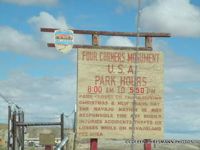
the signage at the entrance to Four Corners


first stop...the restrooms; state park style port-a-potties
the new restrooms are under construction
I can not imagine the lines to these two little buildings
when the tour busses arrive!!!


the medallion is the same


but I think the surrounding medallion has changed
Hubby is sitting on the little 4 states medallion
and sitting IN all four states


there are now 4 ramps and viewing areas for photos
visitors are limited to 3 photos (supposedly)
we were 'required' to take 4 each for geocaching!
plus all the others for blogging and posterity


seating areas, 4 of them, for those waiting to take photos
 or those watching the photo taking process

One of the things we both remembered form the 1972 visit was the hawking of handcrafted items from the Natives. They set up a table and displayed their items, trying to keep them from blowing away, or protecting them from the elements of Mother Nature. We wondered if there would still be the handcrafted items for sale...

again, can't imagine the lines when the tour busses arrive
it certainly wasn't busy when we stopped,
but there was some waiting because nobody takes just 3 photos

...well, of course there would be. After all, it is reservation land, Navajo land. Along with all the new seating and ramps for photos, the Native craftsmen have enclosed stalls. I would guess there are 10 or 12 stalls on each of the four sides of the monument. The stalls are equipped with electricity as one woman told us she had a heater behind the counter. It was windy, but the four sided (open on the corners) protected the interior area, somewhat. No handcrafted items were blowing around.


the state flags at Four Corners, and a few others

Although I took this photo for the flags, it gives a good view of the entrance into the center of the monument area and a great view of the backside of the craftsmen's stalls. Each stall is around 10x10. Maybe a third of the stalls were open for business when we were there, selling jewelry, decorated arrows and knives, sand paintings, horsehair ceramics, dream catchers, and more jewelry.

The parking lot was packed clay, not paved. The ground was uneven, with ruts and potholes. Parking was here and there with no specific designated rows or lines. So that hadn't changed.


signage at the entrance
(no food on the day we were there)


didn't see the Welcome to signs for Colorado, Utah, or Arizona
you can only get there through CO or NM


a mesa along the highway


metal artwork along the highway


and the sign at the elevators in the hotel in Gallup

We stopped at Four Corners primarily because of geocaching. It was a very big deal for the four geocaches to be allowed at Four Corners because it is reservation land. There were placed a year ago last August.  The geocaches do not have containers. We had to answer questions and take photos to prove we were there. Been there. Done that. I can now wait another 47years to see it again. Maybe the parking lot will be paved and the toilets will flush???