Thursday, November 18, 2021

Is It Snow or White Sand?


This the last post as we traveled from SD to AZ. We arrived November 8th and have been busy ever since. 


"Like a mirage, dazzling white sand dunes shimmer in the tucked-away Tularosa Basin in southern New Mexico. They shift and settle over the Chihuahuan Desert, covering 275 square miles - the largest gypsum dune field in the world."


plants: Little Bluestem & Rubber Rabbitbrush


Mesquite Trees? 


"White Sands National Park preserves more than half of this oasis, its shallow water supply, and the plants and animals living here."


The Andres Mountains along the north edge of the Alkali Flat, provide the winds that create and also move and shift the grains of sand. The mountains also provide moisture from snow melt.


In the area we are allowed to drive, we noticed more plant life closer to the southern edge or entrance area of the WSNP. The drivable area is 8 miles in and back out on maybe 5 miles of paved road.


It really looks like snow banks to this girl from South Dakota! We did not see any sledders but did see someone in the gift shop with a sled.


Imagine. It can be seen by astronauts from space.


comparison of other gypsum fields


Looks like and feels like grains of sugar.


"People arrived in the Tularosa Basin after the last ice age ended 11,000 years ago. The Jornada Mogollon were the first to farm the area, and lived here until drought forced them out in the 1300s. American Indians returned in the 1600s and European Americans came in the late 1800s. Soon the railroad rolled in - and so did the settlers."

President Herbert Hoover proclaimed it a National Park in 1933. The US military tested weapons in the dune field beyond the park in WWII and the first atomic bomb was detonated 100 miles north of here in 1945.

We visited the WSNP in 2010. Here is that blog post: Tuesday's Adventures in New Mexico


And finally, an interesting story to go with this photo: We first met this gentleman and his furry friend at the Smokey Bear Historical Park in Capitán NM. The furry companion did not enjoy the forest service video showing at the historical park center. We met them outside on the walking path near Smokey's burial and learned he had also served in Desert Storm. The next time we met was in Alamogordo while we were geocaching at the John Stapp Space Park. Again, we said Hi and we chatted a bit and teased each other about stalking and we moved on.  On the third occasion, we were coming back to the car from the Interdune Boardwalk when the two of them were in the parking lot. I was busy taking photos and looking for animal tracks in the snow...I mean...sand when I noticed Hubby in deep conversation. He finally got the story: The gentleman had lost his wife last year and his furry friend was helping him cope with her loss. The two of them (man and dog) were doing the travel bucket list of places he and his wife had planned but did not get to complete. 

We are blessed.


Wednesday, November 10, 2021

A Drove of Donkeys

 The third town with a MUST STOP was Carrizozo. Hubby had it on his list because of the geocaches. But once again, it was so much more than a geocaching stop.

Carrizozo got its start because of the railroad. Today it is known as an artists community.

The name of the town is derived from the Spanish vernacular for reed grass (Carrizo), which grew significantly in the area and provided excellent feed for ranch cattle. The additional "zo" at the end of the town name was added to indicate abundance of Carrizo grass. The town is now often referred to colloquially as "Zozo".


To the west of the town is the Carrizozo Malpais, a 40-mile-long (64 km) lava flow that is about 1,500 years old. The lava flow is the dark formation between the grassland and the mountains.


To the northeast is Carrizo Mountain, a 9,600-foot (2,900 m) peak within the Sacramento Mountains.


But this set of 5 geocaches gave us a tour of the town's burros and the story behind them.

An attempt to entice travelers into exploring Carrizozo’s art spaces has grown into a Tularosa Basin phenomenon. Warren and Joan Malkerson, expat Minnesotans, turned their sights to this little town southeast of Socorro in 2005 and invested in a “herd” of aluminum burros. They invited local artists to paint the beasts, then set them outside businesses, along the roads, and atop a few buildings. Motorists who noticed them stopped into the couple’s Tularosa Basin Gallery of Photography and their Gallery 408. A feeding frenzy followed. “We’ve sold more than 400 of the painted burros,” Warren says. “They’re in more than 30 states.”


behind these doors...


...a drove of donkeys at Gallery 408


There are 26, maybe a few more, burros throughout the town. Some are advertising businesses, some in gardens and parks, some reside in the yards of the residents.


The original idea of branding the Carrizozo's quirky art scene with burros came from an old photograph that showed the animals standing along the town's historic Twelfth Street that is now home to a thriving artists' community.

"There were feral burros everywhere because people used them as work animals back in the day," Joan said.


Malkerson gets the bare metal forms in El Paso, imported from Mexico, and makes them available to local artists for trimming and sale, or also sometimes for charitable auctions.


 once a thriving community
now homes and studios of artists using different mediums


a gathering place between two buildings
there were other gathering spots along 12th Street


interesting wall art "Crop Circles"
with a geocache under that rock


along US Routes 54 and 380


ice cream shop
it didn't look open for business


keeping an eye on the traffic

They are enough of a landmark that Warren happened to find a picture of a burro perched on top of the Highway 54 Emporium building in Carrizozo while thumbing through a copy of a National Geographic Travel magazine.


watching over 12th Street


my favorite


some of the burros advertise businesses, 
like this one along Highway 380


After exploring the town, we did not see many options for lunch. We drove back to ZZQ and had a wonderful conversation with one of the owners. She commented on the increase in their sandwich business because of folks coming to town for geocaching. The pork sandwiches were delicious!


So, are they donkeys or are they burros? According to Wikipedia:

Burro is a word for donkey in both Spanish and Portuguese. In the United States, it is commonly applied to the feral donkeys that live west of the Rocky Mountains; in some areas it may also refer to any small donkey.

The first donkeys came to the Americas on ships of the Second Voyage of Christopher Columbus, and were landed at Hispaniola in 1495. The first to reach North America may have been two animals taken to Mexico by Juan de Zumárraga, the first bishop of Mexico, who arrived there on 6 December 1528, while the first donkeys to reach what is now the United States may have crossed the Rio Grande with Juan de Oñate in April 1598. From that time on they spread northward, finding use in missions and mines. Donkeys were documented as present in what today is Arizona in 1679. By the Gold Rush years of the 19th century, the burro was the beast of burden of choice of early prospectors in the western United States. With the end of the placer mining boom, many of them escaped or were abandoned, and a feral population established itself.


Monday, November 8, 2021

Smokey Bear's Final Resting Place

 We stopped in Capitán NM after our stop in Lincoln. Capitán was where Smokey the Bear got his famous start.


This community was also influenced by the Lincoln County War, but there was enough of that in the previous post. This is all about Smokey.


a stop on the outskirts of Capitán, looking towards the Lincoln National Forest


At the Visitor's Center, guests find fascinating exhibits about forest health and wildfires, the science of fire ecology, and a historical look at forest fire prevention.  The theater features a short film about how forest health and fire impacts our lives today.


The Smokey exhibits show the history of the bear's journey to stardom.


On the grounds of the park is Smokey Bear's final resting place.

The marker for Smokey's burial site on the grounds of the center.


a headstone of sorts for Smokey


This was the only placard giving information about Smokey. I was thinking we would get answers to 16 questions which would lead us to a geocache, until I read a high clearance vehicle would be needed to reach the final location in the forest near where Smokey was found. Nope. Not us. Not this time.


statue honoring firefighters

So we settled for a walk around the center.  Another interesting location because of geocaching.

And if you are interested, or if you care...

The True Story of Smokey Bear

Capitan, New Mexico is the birthplace and burial site of Smokey Bear. On May 4, 1950, a carelessly discarded cigarette started the Los Tablos blaze in the Lincoln National Forest. On May 6, a second fire, known as the Capitan Gap fire started in the same general area. Together these fires destroyed 17,000 acres of forest and grasslands. The monetary loss to private property was great but the loss to the environment was even greater.

In May 8, a 70 mile per hour wind made it impossible to control the blaze. It was on this day that nineteen men were trapped in a rock slide while the raging holocaust, incredibly, spared them. They were rescued without any fatalities, but later expressed the opinion that they knew "just how a slice of toast feels."

On May 9, a fire crew brought a badly singed bear cub into the fire camp. They had found the frightened cub clinging tenaciously to the side of a burnt pine tree. Badly burned about the buttocks and feet, he was given the name "Hotfoot", a description soon to be changed to Smokey Bear. His burns were tended to overnight at the nearby Flatley Ranch, then flown by Game Warden Ray Bell to the veterinary hospital in Santa Fe. Bell later kept Smokey in his home, where, it is said, he was a "mite domineering" with the other family pets and somewhat of a ham.

In 1944, prior to the discovery of Smokey Bear, the Forest Service and the Advertising Council originated and authorized the use of a poster by artist Albert Staehle, depicting a bear called Smokey. A later depiction by Rudolph Wendelin is still used in fire prevention campaigns. The popularity of the campaign grew so great, after the inclusion of Smokey, that in 1952 Congress passed a bill into law governing the commercialization of the name and image of Smokey Bear. Due to the vast amount of mail he was receiving, Smokey was given his own zip code. Upon Smokey's recovery in Santa Fe, the Forest Service had Smokey flown to Washington D.C.

It is rumored that on this flight, an airport refused the pilot's request to land because a bear was aboard the plane! In July of 1950, the U.S. Senator Chaves of New Mexico, presented Smokey to the school children of America. Smokey was now in his permanent home at the National Zoo where millions visited and marveled at his story.

New Mexico adopted the black bear as the state animal in 1962, and, on its golden anniversary in 1962, a female bear companion named Goldie from Magdalena, New Mexico was sent to the Washington Zoo. No cubs were ever born to Smokey and his mate.

Upon his death in 1976, at the urging of his many friends, Smokey's body was returned to his beautiful and beloved Capitan Mountains. He now rests in peace, buried in a small park which bears his name; in the heart of the Village of Capitan and in the shadow of the mountains where it all began. In 1984, Rudolph Wendelin designed a 20 cent postage stamp depicting a bear cub clinging to a burnt tree with the famous Smokey Bear emblem as a background. This was the first and only time the U.S. Postal Service has issued a postage stamp honoring an individual animal. Capitan was chosen for the first day sale of this commemorative stamp fifty years after the inception of Wendelin's poster.

Smokey Bear, the Lincoln National Forest, the beautiful and rugged Capitan Mountains, are all part of the saga of dedicated and caring people who were brought together by a miracle of nature... all a part of the history of Capitan.

Thanks to Frank E. Miller and Dorothy Guck for providing information for this epic story. Photos courtesy of the Smokey Bear Museum. Aftermath of Capitan Gap Fire, Hopalong Cassidy and Smokey, Homer Pickens & Smokey

~ Smokey Bear - Village of Capitan (https://www.villageofcapitan.org/smokey-bear)


Sunday, November 7, 2021

Lincoln ~ New Mexico, That Is...

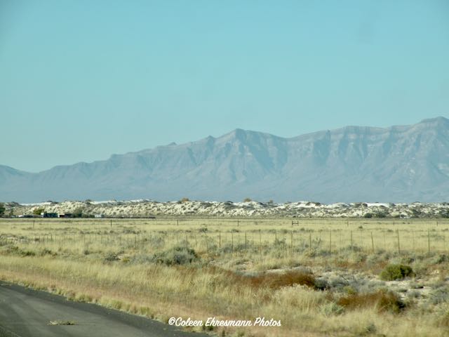
Geocaching friends passed through the ghost town, well, almost ghost town of Lincoln NM recently. One of her photos was very interesting. So when I knew Lincoln NM was on our route between Roswell and Alamogordo, I did some research and convinced Hubby we needed to stop.

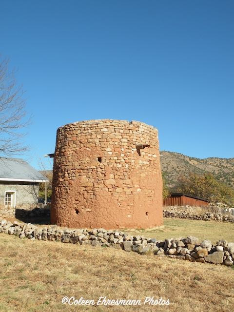
Las Placitas del Rio Bonito means "the place by the pretty river." 


This circular stone fortification was erected by the area’s earliest Hispanic settlers in the 1840’s or 1850’s. The tower has a viga-constructed second floor, and an open-roofed second story. It was used as a look out and defensive structure for protection from raiding Apaches. 


Tradition says the Torreón was at the center of a plaza surrounded by a number of jacales. This plaza was part of a series of settlements known as Las Placitas del Rio Bonito.

The Torreón was restored in the mid 1930’s by the WPA under the sponsorship of the Chaves County Historical Society. It became state property in 1935, and is on the National Historic Register and the State Register of Cultural Properties.


description of the Mexican homes surrounding the plaza


interior of the jacal


sticks and wattle home of the early Mexican settlers
one room house


The Lincoln County War was an Old West conflict between rival factions which began in 1878 in New Mexico Territory, the predecessor of the state of New Mexico, and continued until 1881. The feud became famous because of the participation of the criminal William H. Bonney ("Billy the Kid"). Other notable participants included Sheriff William J. Brady, cattle rancher John Chisum, lawyer and businessman Alexander McSween, James Dolan and Lawrence Murphy.

Some of the above mentioned names should be familiar: John Chisum the Cattle King in Roswell and Billy the Kid buried at Fort Sumner.


The conflict began between two factions competing for profits from dry goods and cattle interests in the county. The older, established faction was dominated by James Dolan, who operated a dry goods monopoly through a general store referred to locally as "The House". 


Murphy-Dolan Store


later home of county government and judicial offices


And finally the building and story that originally caught my eye in this historical town...

This is one of Lincoln’s earliest intact dwellings.  The oldest two rooms of this rambling structure were built prior to 1861.  

During the Five-Day Battle in July 1878, a contingent of the McSween faction occupied this building.  Early in the battle, only about 15-20 McSween men were present in the store, and most of the fighting took place further to the west. However, on Wednesday—July 17th—the situation began to deteriorate.  When Isaac’s son Ben Ellis stepped out of the house shortly after dark to feed his mules, he was shot through the neck.  Attempts to bring Dr. Taylor F. Ealy from the Tunstall Store to the Ellis Store were turned back by gunfire.  Ealy was able to treat Ben on the morning of July 18th, and he survived his wound.  Then Colonel Nathan Dudley of Fort Stanton arrived in Lincoln and drove about a dozen McSween men out of the Montano Store about noon on July 19, 1878.  Most of them fled east to the Ellis Store.  When Colonel Dudley then trained his mountain howitzer and Gatling gun on the Ellis Store, all of the McSween men in the east end of Lincoln were forced to leave town.  Thus, the intervention by Colonel Dudley allowed Dolan’s men to focus on the McSween house, which sealed the fate of Alexander McSween.


After being expanded by Elisha Dow in the 1870s, the building was purchased by Isaac Ellis and used thereafter as a boarding house, store and ranch headquarters.  Ironically, Ellis moved to Lincoln County in the summer of 1877 in order to escape the violence of the Colfax County War. 

Do you get the irony? Ellis left Colfax County to escape the county war but by opening a competing story and business in Lincoln, he in fact, was embroiled in the Lincoln County War.


English-born John Tunstall and his business partner Alexander McSween opened a competing store in 1876, with backing from established cattleman John Chisum. The two sides gathered lawmen, businessmen, Tunstall's ranch hands, and criminal gangs to their assistance. The Dolan faction was allied with Lincoln County Sheriff Brady and aided by the Jesse Evans Gang. The Tunstall-McSween faction organized their own posse of armed men, known as the Lincoln County Regulators, and had their own lawmen consisting of town constable Richard M. Brewer and Deputy US Marshal Robert A. Widenmann.

The conflict was marked by revenge killings, starting with the murder of Tunstall by members of the Evans Gang. In revenge for this, the Regulators killed Sheriff Brady and others in a series of incidents. Further killings continued unabated for several months, climaxing in the Battle of Lincoln (1878), a five-day gunfight and siege that resulted in the death of McSween and the scattering of the Regulators.


Pat Garrett was named County Sheriff in 1880, and he hunted down Billy the Kid, killing two other former Regulators in the process. (Sheriff's office was on the second floor of the building.)


Now back to the Ellis Store and the part that caught my interest...

For the next 20 years, the Ellis Store served primarily as a private home.  But in 1901 Dr. James W. Laws came to New Mexico from Memphis, Tennessee, after discovering that he was himself a victim of tuberculosis (then often called the ‘white plague’).  Dr. Law was cured of the disease at Fort Stanton Tuberculosis Hospital by 1904. Inspired by the care he received at Fort Stanton, Dr. Laws bought the Ellis property and expanded the buildings in order to convert it into a sanitarium for patients suffering from tuberculosis.  One of the buildings behind the main house near the river was originally a grist mill located lower on the Rio Bonito.  It was moved here by Dr. Laws and renovated to serve as housing for his nurses.  The patients lived in cottages in order to maximize their exposure to the pure, dry mountain air of southern New Mexico.  Dr. Laws, his wife Grace Austin Laws, and their son Otis Laws operated this small ‘ranch sanitarium’ here from 1905-1918.  They moved to the El Paso area in 1919 to open another sanitarium.

it is now a private residence


La Iglesia de San Juan Bautista, or Church of John the Baptist
built in 1887
The Roman Catholic Church is open to the public 
and is still used for services today. 


Lincoln has numerous (17?) historic structures, nine of which are open to the public as museums operated by New Mexico Historic Sites. These include the Courthouse where Billy the Kid killed deputies James W. Bell and Bob Olinger, the Tunstall Store, the Convento, the Torreon and others.


2010 population census of Lincoln was 189

The village is centered around a 1 mile stretch of U.S. Route 380 (also known as the Billy the Kid Trail, which is the village's only street. Numerous historic structures dating as far back as the late 1800s still remain, many of which have been preserved and now operate as public museums.

Today, Lincoln NM is best known for...

We do not know it the Last Escape of Billy the Kid still happens in August. The pageant grounds were overgrown grass and the bleacher seating looked in need of repair. I will say there were 3 staff members in the Lincoln County Museum when I entered. I did not ask a lot of questions at the time. I maybe should have...

PS: The stop in Lincoln yielded 4 geocaches!