Saturday, August 28, 2021

Squirrel Bridges

As you know we recently visited friends in Long Beach, Washington on our month-long camping and caching adventure. The four of us, Jon & Sherry and Hubby and I have had some great geocaching adventures in SD, AZ, OH, MN and now OR and WA have been added to the list.

Sherry took us to the community of Longview to do some special geocaching. And it was! The highlight, other than the walk-in Ammo can was our tour of the Squirrel Bridges. Yes, you read that right. Bridges for squirrels.

This is the bridge that was the beginning, Nutty Narrows Bridge. (The original has been replaced due to wear and tear and has been moved several times)

The Nutty Narrows Bridge was built in 1963 by a local builder, the late Amos Peters, to give squirrels a way to cross the busy thoroughfare without getting flattened by passing cars.

The original bridge was built over Olympia Way on the west edge of the library grounds. Before the bridge was conceived and built, squirrels had to dodge traffic to and from the Park Plaza office building where office staff put out a nutty feast for the squirrels. Many times, Peters and others who worked in and near Park Plaza witnessed squirrels being run over.

One day Peters found a dead squirrel with a nut still in its mouth, and that day’s coffee break discussion turned into squirrel safety. The group of businessmen cooked up the squirrel bridge idea and formed a committee to ask the City Council’s blessing. The Council approved, and Councilwoman Bess LaRiviere jokingly dubbed the bridge Nutty Narrows. The name stuck!

After architects Robert Newhall and LeRoy Dahl designed the bridge, Donald Kramer completed structural engineering, and Amos Peters and Bill Hutch started construction. They built the 60-foot bridge from aluminum and lengths of fire hose. It cost $1,000.

It didn’t take long before reports of squirrels using the bridge started. Squirrels were even seen escorting their young and teaching them the ropes. The story was picked up by the Associated Press, and Nutty Narrows became known in newspapers all over the world. Animal lovers in London, Minnesota and California sent newspaper clippings, fan mail and bags of nuts to Peters. One man wrote, Little men take time to cater to big people who might do them good. Only big men pause to aid little creatures.

In 1983, after 20 years of use, Peters took down the worn-out bridge. Repairs were made and crosspieces were replaced. The faded sign was repainted and in July 1983, furry guests from Disneyland (Chip and Dale and Mickey Mouse), local dignitaries, and 300 children rededicated the bridge.


Most of the squirrel bridges are along Lake Sacajawea, a park in the city of Longview with big old trees along the north side of the lake and along the street across from the park.


R.D. Olson Bridge
This bridge was built by R.D. Olson MFG of Kelso Washington and was designed to resemble the Lewis and Clark Bridge crossing the Columbia River. It was installed on Kessler Boulevard across from the Lion's Island.


Public Utilities District #1 Cowlitz County Washington

The aluminum bridge was designed by a PUD engineer and built by a mechanic to deter what Dietz called "the No. 1 cause of outages in Cowlitz County: squirrels." It is the eighth bridge added to the squirrel bridges in Longview.


Bruce Kamp Bridge
Built in 2011, it was designed with copper and is the first squirrel bridge to utilize a webcam. Located on the 1300 block of West Kessler Boulevard. (No web cam on our visit)


Fremont Bridge
This all-aluminum bridge was constructed by H&N Sheet Metal in Kelso. It is the longest bridge to date at 20 feet and is located on Kessler Boulevard at the end of Lake Sacajawea. It is a replica of the Fremont Bridge in Portland Oregon.


John R. Dick Bridge
Inspired by the famous Leonard Zakim bridge in Boston. Built in 2012, and located at 2900 Nichols Boulevard.

There are plans to add more bridges along Lake Sacajawea.


Peters died in 1984, and a ten-foot wooden squirrel sculpture was placed near the bridge in memory of its builder and his dedication to the project.


All because of geocaching! Another great adventure. Thanks Sherry!

*Italicized info was taken from several sources about the squirrel bridges.


Friday, August 27, 2021

Carhenge, Like Stonehenge, but Cars

 We are spending a few extra days in Nebraska on our way home. The reason is geocaching, of course! And once again, we happened upon a most interesting location. Carhenge. 

I had to buy a Nebraska map at a truck stop. The Visitors Centers along Interstate are closed, so no free state maps. The Visitor Center in Ogallala was also closed. We had a geocaching plan involving 13 counties and lots of miles, but since both of us are visual, we prefer a large paper map to mark our routes. The truck stop map had locations of interest on it and Carhenge was on our route for the day.

I had heard of it through the geocaching website, but other than hearing about it, I knew very little. As we were driving through the northern panhandle counties I did see a bill board, but again, other than seeing it, I had no idea.


"Carhenge is a replica of Stonehenge, England's ancient alignment of stones that chart the phases of the sun and moon. Created from Vintage automobiles, the dimensions of Carhenge replicate Stonehenge. The cars are primarily from 1950s and 1960s. They are planted trunk down and rise 15 to 17 feet. The cars are approximately 7 feet wide; the same size as the standing stones of Stonehenge." ~ brochure


WHY? Creator Jim Reinders says, "Why Not?"
Jim spent 7 years as an engineer in England. When he returned home to Alliance, Nebraska he brought with him a grand idea to recreate Stonehenge, but to do so using materials readily available. Old cars. The cars are of similar shape and size as the Stonehenge stones, and the wheels would provide stability to the structure.

The original 25 cars were erected (see above photos) during a Reinders family reunion in six days and dedicated on the Summer Solstice June 21, 1987. "We were able to reduce the time of the original Stonehenge construction by 9,999 years and 51 weeks."~ signage

More history can be found at this website: History - Carhenge


all 38 of the major stones at Stonehenge are cleverly represented
Carhenge gets painted every so many years. I did not see any graffiti on any of the gray painted cars.

The 10 acres also features a number of sculpture pieces made entirely of cars and or car parts.


dino built by Merle Stone of Hemingford


Benches created from pick-up/truck tail gates and wheel rims.


Car-nestoga by David Kowalski created as a tribute to the pioneers crossing the plains on the Oregon Trail in wagons.


The three bells, built by Leonard Reinders, representing the three Reinders siblings (Phyllis, Leonard, Jim).


The autograph car is on the left of the photo. Jim Reinders created The Four Seasons to the right of the autograph car. The yellow represents fields of wheat in summer and fall; the green referring to planting in the spring, and the whites representing the wind swept, snowy plains of winter. The Four Seasons are all Fords.


Hubby is autographing the car with his geocaching name. This was one of two geocaches at this location. For the geocachers reading the blog: GCGN58

There is a gift shop and campground on site. The gift shop was not open, but we stopped at the museum in Alliance and found some souvenirs of Carhenge.


You can compare our visit to Stonehenge England here.

We have been to two other car sculptures because of geocaching:


Monday, August 23, 2021

Twin Falls ID

 We have begun our journey back to South Dakota. We spent a couple of nights in Twin Falls ID. This is what we saw, or at least what I think is the highlights.


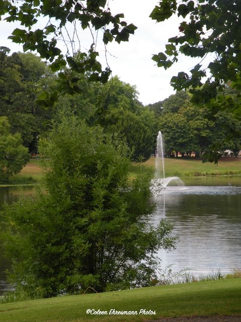
Our first destination was Centennial Park, along the Snake River. The town of Twin Falls is on the canyon ridge behind us as we snaked our way down to the park. There was a golf course at the park and options for launching canoes, kayaks, water boards, and maybe boats although I did not see any boats.

This green and fertile valley was the ranch of Ira Perrine, founder of Twin Falls.

Perrine was a farmer and rancher and responsible for getting a dam built on the Snake River to help bring water to the land on the ridge. His family lived on Blue Lakes Ranch until 1964 when the land became the Blue Lakes Country Club, the golf course you see in the first photo.


One of the water falls along the canyon wall driving the road to Centennial Park.


The Perrine Bridge is Highway 93 crossing the mile wide Snake River. The bridge has walking paths on the two sides. We stopped at the Visitors Center for the next photos.

The Perrine Bridge is approximately 1,500 feet (457 m) in total length, with a main span of 993 feet (303 m) and a deck height of 486 feet (148 m) above the Snake River it is the eighth highest bridge in the United States. The elevation above sea level for the bridge deck is approximately 3,600 feet (1,100 m). ~ Wikipedia


Someone on a Paddle Board on the Snake River.


And some kayakers. There were several. 


This area has a history of volcanic activity. Lava rocks are used all over the city-rock walls, landscaping, trails and foot paths.


The Perrine Bridge is also the location for BASE jumping. (Click to enlarge the photo.The jumper is wearing blue and his parachute is orange and white.) 

The Perrine Bridge is a popular BASE jumping site known all over the world; it may be the only man-made structure in the United States where BASE jumping is allowed year-round without a permit. Jumpers often use the nearby visitor center as a home base before and after parachuting from the bridge. ~ Wikipedia


Hubby talked to one guy rolling and packing his parachute. He had jumped twice that day and was planning to do a third. We saw vehicles in the Visitor's Center parking lot with BASE jumper stickers. One van was equipped as a camper with food stuffs to rival the travel trailer pantry. So these are serious enthusiasts who travel great distances to jump off a bridge! 

We stopped at the area twice, and each time 3-5 guys (mostly) were rolling and packing chutes. As we left the last time, a woman (younger) had slipped into the harness and one the 'professional' BASE jumpers was taking her to the east side of the bridge for her jump. I say 'professional' as I got the impression one could hire them to use their knowledge and equipment IF one so desired to jump off a bridge nearly 500 feet above the water. We did not stick around for her jump, but she was on the deck as we drove toward the campground.


The Shoshone Falls are several miles northeast of the Perrine Bridge and Twin Falls. It is the location of the first of several power plants. 

Sometimes called the "Niagara of the West," Shoshone Falls is 212 feet (65 m) in height, 45 feet (14 m) higher than Niagara Falls, and flows over a rim nearly one thousand feet (300 m) in width. ~Wikipedia


A rainbow at the base of the falls.


We drove farther to the east to the location of Twin Falls and another hydro plant.


Water flows westward over Twin Falls and is controlled by the Twin Falls Dam, built in the 1930s and used for irrigation and hydroelectric power generation. There were originally two parallel falls, but the dam permanently diverted the flow from the southern falls, leaving a single (north) waterfall.


And speaking of irrigation and agriculture, this poster at the Visitors Center says it all. I also learned Idaho is the third largest state producer of dairy (milk). At one time milk from Idaho was trucked to the Lake Norden cheese plant.


Another claim to fame for Twin Falls is the Mile Long Leap of the Snake River by Evel Knievel in 1974.


This is the ramp Knievel used to launch his flight. (a dirt hill with some remaining concrete on the upside) A 180 foot structure was atop the dirt hill.

He invested nearly $1 million dollars in the stunt. He leased 300 acres for the fans, television crews, and support staff. The cost was $35,000 for the fee and legal permits.


This is looking across to the north rim, 1 mile away. The jump was unsuccessful. The ramp and the X-2 Skycycle were designed and built by Bob Truax, but rather than a high powered motorcycle, he created a rocket. 

Here is a youtube video link to his jump: Evel Knievel & the Snake River


It was interesting to me to read the successes and not so successful attempts of Evel Knievel. The American Icon had 70 different stunts, 433 broken bones (a world record), and survived every feat.

On September 16, 2016, stuntman Eddie Braun did what Evel did not: he successfully jumped the Canyon in a rocket motorcycle built by the son of the man who built the original rocket motorcycle. It was named "Evel Spirit" in Knievel's honor.

Wikipedia has an interesting bio of Evel Knievel if you are interested.


Thursday, August 19, 2021

Our Destination

 Not as many words for this post. Photos with captions.


the view at the end of the tunnel somewhere in Washington


not more smoke filled skies!!!


actually...it was rain, ~ well...mostly drizzle


FINALLY! 
our destination on day 16
in the driveway of Jon & Sherry


first stop ~ the beach
and the end of the kite festival activities for the day


the beach ~ to capture a sunset


a geocaching event the next morning
hosted by geocachers from France


remaining sand sculptures from the event a couple of weeks ago


Huckleberries
about the size of a small pea or chokecherry
these are NOT at the ripe stage


walking the sand dunes for a geocache


geocache in the drift wood (huge trees) on the beach


the bridge connecting Washington and Oregon


wild blackberries