The following day we showed our Ticket-to-Ride reservation to the park entrance staff and were waved into the park. (You only get in with a day pass reservation made online MONTHS in advance, on a tour bus, or the Ticket-to-Ride reservation, also made MONTHS in advance.) We were in! For a moment I thought about telling Hubby to keep driving and bypass the parking lot for the shuttle buses. But common sense prevailed and we followed the rules.


Glacier National Park is 1584 square miles of protected landscape or one million acres. The park was established in 1910 when President William Taft signed a bill into law establishing Glacier National Park. The area above the dotted line is the Waterton section of the park in Alberta. In 1932 the two parks were designated the world's first International Peace Park to commemorate the bonds of peace and friendship between two nations.

One of our shuttle buses. Some were maybe twice as long as this one. This one held 12 seated passengers. Hubby was getting info and thanking her for a fabulous ride.
I had two reasons for wanting to go from east to west on the Going-to-the-Sun Road. The first was to see both sides of the park without having to drive and the second was for geocaching purposes. Only virtual and earth caches are allowed in national parks; there can be no containers, only look and see and record what you saw geocaches. There were 7 such geocaches along the GTTS road. My plan was to ride the entire length and determine how many of the 7 geocaches we could get by riding the shuttle.
Our reservation was for 12 to 1 to register and get a wrist band then we could ride the rest of the day. We registered before 12 and boarded a bus immediately. We were the only two riders.
What we did NOT know was the shuttles had different stops; our first ride made 4 stops before going back to the east entrance. So we had to wait for another shuttle (about 15 minute wait) to continue our east to west journey. In 2021, the shuttles do not stop at all the shuttle stop locations due to lack of staff and maybe covid. So riding all the way to the end would help us know if we could get off at a location to find a geocache.

Sun Point
Once we realized we had to wait for another shuttle we quickly found the trail and climbed to the top of the hill for a fabulous view of Saint Mary Lake. Some blue sky. Some clouds for photograph interest. Still some smoke from forest fires haze.

A bicyclist with all his camping gear endangering his life on GTTS road. Brave and crazy man as the road was narrow. There was no shoulder. Ever.

This was my view at Logan Pass, the not-so mid way point on the GTTS road. The lady driver in the above photo said the east to Logan Pass was about 18 miles and Logan Pass to west was 30 miles. See that beautiful blue sky? We were in short sleeve shirts and shorts. And the parking lot at Logan's Pass was just as full. People drove around and around waiting for someone to leave.

flowers at Logan's Pass
wild asters???
phone camera captured the lavender color where my camera does not

similar to Indian Paintbrush, but I think they have a different name
no cell service so no plant snap

This is how most of the GTTS road looked west of Logan Pass. Tree lined, starting with evergreens/firs and ending with deciduous/aspen and cottonwoods. A very different pretty. No waterfall views, but running streams.

After getting off at Apgar for a bathroom break, we boarded the shuttle to head back east. Our first stop was at Lake McDonald. One of our geocaching stops.

But first the lodge. The lodge is a 3 ¹⁄₂-story structure built in 1913 based on Kirtland Cutter's design. The foundation and first floor walls are built of stone, with a wood-frame superstructure.

main room light fixture

the steps of the stairway

the timbers and the wildlife
We found the geocache location on the shore of Lake McDonald behind the lodge. We saw the line for food and drink and decided to head up the street to the store across from the shuttle stop.

flowers in front of the camp store

The west side of Glacier has less rugged mountains, fewer glaciers (like maybe none), green trees and green valleys, and many streams/rivers along the road.

The sky was perfect for photos, even through the van windows.

The elevation at Lake McDonald was 3153 feet. The elevation at Logan Pass was over 6000 feet. (last blog post) As we climbed out of the valley floor the rugged mountains were more prevalent. One would expect in a 3000' drop the road would have many switchbacks. Not so. Our driver Dan (from Sun Tour) told us the engineers had 13 switchbacks planned for the road when it was constructed in 1933. That did not please some powers that be. A new plan was developed and to this day there is one switchback on the drop from Logan Pass to McDonald Lake.

I can not find a name for this peak on my map. It was stunning because it glistened in the afternoon sunlight as we headed up towards the pass. In some of my photos, it is all glare, it was so shiny. It was near Avalanche Creek/Lake. (photo through the shuttle window)
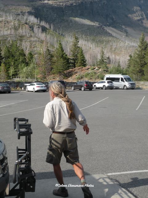
He was one of our shuttle drivers. Look at his hair! Braided dreadlocks.

There must have been a bridal photo shoot at this shuttle stop.

This was the view at our last stop, waiting for a shuttle. We had our longest wait at the end of the day, but that was okay because we visited with a family of 5 from the Chicago area who got involved with geocaching during the pandemic year. We had lots to talk about! This was also the stop for the wedding party photo and the van driver. Before we boarded our shuttle several deer walked through the northwest corner of the parking lot. Two little fawns were in the deer party.
We arrived at the visitor's center about 6:30. The shuttles run until 7 PM IF you are between Apgar and the Visitor's Center.
Summary: I was disappointed in Glacier Park after the Sun Tour. Maybe it was because of the cloudy skies. Maybe it was because the tour was not all I had expected. I thought I would get some park history or information during the driver's commentary. I thought we would be driving all 48 miles of the Going-to-the-Sun Road. Maybe the non-interaction of our fellow tour riders was part of the let down. After the tour Hubby asked me how I thought Glacier compared to Yellowstone. My answer was it is like comparing Zion and Bryce. You can't because they are so different. I went back to the camper unimpressed with Glacier National Park.
Thank Goodness we followed through with the Ticket-to-Ride the next day. Although our shuttle drivers gave no commentary, every now and then one of them would point out something of interest. The sky had cleared, mostly. (It was still hazy on the east side.) The sky was blue with some clouds, making for better photos. The scenery was so different on the two sides, beautiful in their own way and making it much more interesting. We visited with mask wearing people on the shuttle buses, making the rides more interesting. I came back to the camper at the end of our half day in the park pleased, satisfied, and uplifted. The two and a half year wait and planning to see Glacier National Park was worth it.
No comments:
Post a Comment
Thanks for your comments!