We spent Friday afternoon driving around trying to find the code words for the 10 LAB caches throughout the community. The LAB caches took us to historic and well-known Yuma 'businesses'.

We also stopped near a date farm, a peanut farm, a camel farm, a Sonoran Desert Garden, a freight train, the Yuma Prison cemetery, a minuscule mission, a museum, and City Hall.

The City of Yuma Aeronca Sedan plane, displayed in City Hall.

One of the murals in city hall depicting fueling the 'City of Yuma' plane

Glass & metal display in City Hall

Yuma is 100 years old in 2014

One of 3 murals also in City Hall
Friday ended with the Flash Mob event in the last post.
Saturday started with an event at 7:00 AM. Yes, 7:00 A.M.

Geocachers gathered at the Howard Johnson parking lot

We saw a number of geocachers from this part of AZ in attendance

But coffee was what I really wanted!
We did some geocaching along 4th Street on the way to the next event, 9:00 AM. I did get my coffee, but hubby drank it, by mistake. After the second event we drove across the border to California for a day of collecting caches on a trail, some of which we had started last winter. We now have 100+ CA caches.

Our first stop was the Tatooine Dunes
This area is part of the Algondones or Imperial Sand Dunes
The Return of the Jedi was filmed in this area

The area was part of the Pacific Ocean 200 million years ago
It was rather quiet for 10:00 on a Saturday morning

Yes, another cemetery
We think a small church used to be nearby
"The town of Ogilby is now a ghost town. Ogilby had been a small town of workers for the American Girl Mine and a loading area for the Southern Pacific Railroad. All that remains of Ogilby is the foundation of the school house and the cemetery. The two lie only about 50 feet apart. According to the book, "Southern California's Best Ghost Towns" by Philip Varney, this cemetery was established in 1878. The proprietor of the Gold Rock Ranch R.V. Resort, which lies about 5 miles north, says that Ogilby Cemetery is mostly made up of Chinese who worked for the Southern Pacific Railroad. I did, however, notice some graves with candles depicting the Virgin Mary, and another with a rosary around it, indicating Catholics, perhaps Mexicans. There are no inscriptions on the grave markers. 26 graves were identified. Submitted by: Steve Johnson"
Foundation remains
(not my photo; copied from http://www.ghosttowns.com/states/ca/ogilby.html)

I found this marker quite interesting
Jess (1932-2007), the road grader operator
Not sure if he is buried there or if it is just a memorial marker

A partially buried truck in a wash

The Hedges Cemetery
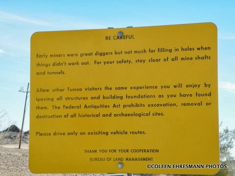
"This is near the Hedges Townsight. The community was originally called Gold Rock Camp. The name was changed to Hedges in 1893, which was later changed to Tumco. There is much histoy in the area. Hedges grew to 2,000 persons. The main town and mines are closed to vehicles, but the cemetary can be accessed by vehicle. Early 1990's a few graves could be found. Recently rocks have been placed to simulate graves."

Artificial flowers decorated each pile of rocks

Hedges, a mining town
"In 1896 Hedges had 3000 residents with a store, hospital, several bordellos, casino and 4 saloons along Stingaree Gulch. In 1862 a wandering mule from a wagon train was found in the gulch with a gold nugget just lying there. In 1910 TUMCO (an acronym for The United Mine Company) took over the area which had a 40 stamp mill. TUMCO put in 60 more stamps and with not enough ore and the added expense, they went broke in 1916. Equipment was sold for junk and that was it."

We did not take the walk to the ghost town of Hedges
It's there in the mountains
Saturday ended with another event, this time dinner
where we ate with and visited with geocachers from CV
and Apache Junction.
Another fun day at the Mega Event weekend!
Sunday's event is the next AND last post.

No comments:
Post a Comment
Thanks for your comments!