Monday, May 21, 2018

The Reason for This Adventure

There were several reasons for taking the road trip we are on this week. The health issues of this past winter and the surgery happening next month had some influence. We had planned to attend a 'big' geocaching gathering in Lincoln NE on the way home in April, but didn't, so this BIG event later this week was to make up for missing the earlier one. We know other geocachers attending this one and look forward to seeing our geo-friends. But the biggest reason was what happened today.

I (and sometimes, Hubby) have goals in this game of geocaching. One of our goals for 2018 was to find double digit (10 or more) geocaches on each day of the calendar year. We completed that goal in April. Now all 366 days have 10 or more logged geocaches. In 2017, one of my goals was to find a geocache in each of the 15 counties of AZ. We had done that for SD and because we spend almost half a year in AZ, I wanted to complete the AZ map. We did. Having goals helps keep the fun of the game alive. My goal for 2018 was to find a geocache placed/hidden in each month since geocaching was created.


See that blank month? August 2000? There are only 3 geocaches in the United States left that had been placed in August 2000. One is in Utah. Another in Georgia. The third in Michigan. Finding that Michigan geocache was the priority for today.


And there it is! A large plastic jar covered in camo duct tape, placed under some sticks. Nothing very special. It was a 300' or so walk from a non-maintained country road, easily accessible with the truck.


trees with itty bitty white flowers


patches of pretty white flowers

This is similar to the area we walked to get to that much needed geocache, except it was not flat ground! And you noticed the walking stick we used to reach that hidden geocache.


don't know what they are called
other than dandelions, this is the only flower we saw today


Since we were driving through Michigan from north to south, we were also looking to find and sign a geocache in each county we encountered. As soon as we saw a sign along the road indicating a county change, I grabbed my phone and looked for a nearby geocache. Sometimes we really lucked out!


This cache talked about a training area for the 101st Airborne during the Vietnam Era and the fact some soldiers went AWOL. So we pulled off the freeway, parked the truck and took a short walk in the nearby woods. This is what we saw.


ammo can hidden under the tarp
VERY creative geocache hider


We also stopped at a sculpture memorial honoring the Michigan DOT workers who have been killed in senseless traffic accidents. A very cool sculpture at a welcome center and a good reminder as we travel the roads.


two more counties to get tomorrow
the green counties show where we have traveled
the green one in the lower left was a county we visited
in 2014 or so when we stopped to visit friends

On to Cincinnati and GeoWoodstock...

Sunday, May 20, 2018

WI to MI of our Geo Road Trip

Today was an awesome travel day as most of it was along the shoreline of the Upper Peninsula of Michigan, all new territory for us.


What I though was Lake Michigan was Green Bay, according to the map. It was a big body of water, but parts of Wisconsin could be seen to the east. I know. Weird! We were driving in Michigan, but Wisconsin was to the east. (Look at a map.)


One of the exciting stops today was at a light house, a working light house. I have seen them before, but not quite this close and personal. The walk was a half mile out and then back again. The walk started on a board walk, went to sand, then boulder climbing, before getting to the cement causeway/walkway/pier. (A chilly 51º along Lake Michigan.)


this guy was at the top of the light house waiting for 
our arrival


the final walk
we needed a photo on the steps of the
light house for a geocache

This 34 foot tower was established in 1915 and automated in 1969.


mileage signs at the parking lot


What we first thought from a distance was smoke was actually swarms of insects. More about that later.


first view of Mackinac Bridge


The bridge opened in 1957, connecting the Upper and Lower Peninsulas of Michigan. It is the world's 19th longest suspension bridge at 26,372 feet long or almost 5 miles long. We traveled north to south, from the UP to the Lower P.


The width of the bridge measures 54  feet. It rises 200 feet above the water level. Approximately 11,600 cars cross it every day. (It wasn't that crowded today. With construction, some of the four lanes were down to 2 lanes.) The bridge cost over $99 million to construct.


Old Mackinac Point Lighthouse in Mackinaw City
on the south side of the Mackinac Bridge
now a historic site under renovation


the bridge looking north
from whence we came...Straits of Mackinac
separating Lake Michigan and Lake Huron


Remember those swarms of insects I mentioned? Well, there were so bad in Mackinaw City, we walked with our heads down, swatting everywhere.


that is not smoke coming from the chimney
that is swarming insects


a tug towing an equipment barge on Lake Huron


that is how bad the insects were
in your mouth, eyes, ears
they covered our clothes and got in the truck
when we got in the truck
ICK! YEW!
but we got the 3 needed geocaches!


The adventure continues tomorrow in Michigan as we head south towards our goal of Cincinnati.

Saturday, May 19, 2018

Celebrating Birthdays

OFD's birthday was earlier this month, but because of our later than usual departure from AZ, we were unable to celebrate with her until this weekend. We had brunch together at one of our favorite places close to her home before we headed on down the road.


Hubby and I then continued on our birthday road trip to Cincinnati by way of...Wisconsin today. We did some geocaching which is the purpose of this road trip. We collected some new counties in WI and found a couple interesting caches. And missed an interesting one.


an easy army tank find


we really hoped to find the cache in Curtiss
but a birthday party at GZ cut short the hunt
(family will know the significance of this town!)


we were in horse & buggy country


tried to get a photo of the horse
but the iPhone didn't cooperate


but this phone geocache did


very clever


well-concealed


then it was birthday dinner in Wausau
spring strawberry salad & wine & yummy warm bread


Hubby's spaghetti dinner


my chicken & vegetables lasagne...yummy!


pie from a favorite place for dessert
can you guess which piece was chosen by Hubby?


birthday celebration started on Thursday with dinner
and flaming cupcakes~all with good friends

And another birthday is in the books!
The Geo-Road Trip continues tomorrow
New places, New adventures...


Tuesday, May 15, 2018

Traveling Through Southeast CO

We traveled through a part of Colorado on the way home this time, seeing an area we had not before and geocaching to break the monotony of travel. And as is very typical of geocaching, we encountered some interesting stops.


a house built of petrified wood


now part of a used car lot


the 'grout' used to hold the stones in place


built in 1933


We were driving through small towns, some without any businesses so finding a place for lunch was beginning to be a worry. We happened upon a little gas station/convenience store and took advantage of the restrooms as well as fuel. We had planned to purchase their Chester's Chicken when the staff recommended the homemade chicken pot pie which had just come from the oven. I took their recommendation. OMG! So good. Lots of chicken chunks and veggies and the crust was flaky, buttery and oh, so yummy! We also purchased the homemade lemon loaf for dessert. This little unassuming local business was the treat of the day.


The next unexpected surprise was a geocache at a Japanese Relocation Camp from WWII.


Camp Amache hosted 7300 American Japanese
from August 1942 to October 1945
(more than 10,000 residents in those 3 years)


some 560 buildings~2000 children attended school~9500 acres
the tenth largest community in CO at the time


The site was brought to the attention of the public in 1976 when some of the interred residents and their families came back to visit. All of the buildings were gone, but they began to tell the stories of their time in Colorado at the camp. Today the community of Granada and its high school students maintain the site, collecting oral histories and the upkeep of the site and cemetery.


Another unexpected stop was the location of a prairie fire April 10, 1948 burned 50,000 acres.
 
Four men, ages 21-37 lost their lives plowing a fireguard to save lives and property. A small memorial along  the highway.


There was a variety of scenery and land formations along that route, everything from high plains desert to rich farmland and oil wells. An interesting drive with some interesting history...thanks to geocaching!


Sunday, May 13, 2018

Spring Soccer

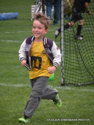
We got to SD on Friday afternoon to greet the g'kids when they got home from school! So good to see them and their parents! Saturday afternoon was spent watching soccer. 50º, damp and a wind out of the north...spring in SD!


Miss W and g'pa playing a little soccer
until she left for the playground


diving the yellow team into 2


Dad coaching M's group


finally shirt over the jacket


so much fun to watch
and see the improvement since last fall


notice all the adults with blankets!


G'pa and M trying to stay warm


By Sunday afternoon it warmed enough to have the doors open at the house and to be outside playing in the dirt. All those AZ tubs can wait for another day...