After some research as to what would be the Must See places versus all the geocaches, we opted to go as far as Furnace Creek CA. I'd say this is maybe the heart of Death Valley as the most popular stops are south of this area. There is more Death Valley north of there, but from what we saw today, we saw the best places. Our original thought was to drive to Bishop CA, a MUCH longer distance, and probably not realistic with all we thought we could see (and geocache).
I am not certain what I expected at Death Valley, other than a white, salt covered dry lake bed. It is a valley, so I guess mountain ranges would be part of the scenery. I wasn't expecting the mountain ranges we did see.
I am not going to post a lot of commentary. You all are capable of looking up info on Death Valley. I will share tidbits on a few of the photos. I really will try to pair down the photos to a manageable number.


FINALLY
the white, salt covered dry lake bed

area called Devil's Golf Course
we were asked to use one of our senses at this stop
which do you think we used first?

hearing
on some occasions, you can hear the salt crystals shift

called pinnacles, the salt crystals are rugged & sharp
brown colored because of blowing dirt & dust
this area, because of elevation never floods

tastes like salt, cause we tasted it

down the road aways is what I think of as Death Valley

I am standing below a sign on the side of the mountain
it is a white mark near the top of the photo,
a little off center to the left
can you see it?

that's what it says
cool, huh?

the sign says 282' below sea level
the GPS said -305'
it was 80º at 2:45 PM, Monday April 11


not as 'rough' as Devil's Golf Course,
but certainly not smooth

the white smoother area is from people walking out to
the center of the dry lake bed

there really is water at Bad Water,
the lowest point in the Western Hemisphere


the ancient aquifer pool
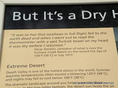
quote on the 1934 record high temp day in Death Valley

a lone purple flower

the abundant blooming flowers are no more
some stragglers

mountains to the east of Death Valley
Amargosa Range


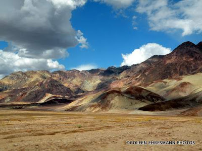
Artist's Palette

beautiful colors because of:
iron, aluminum, magnesium, titanium, and other minerals

narrow one-way road

Salt Creek

Pupfish in Salt Creek


more remnants of abundant flowers last month
More from Death Valley later...
No comments:
Post a Comment
Thanks for your comments!