With Plan B in place and the two of us comfortable with it, it was time to hit the road and collect geocache finds in some more Texas counties. I am including a couple of maps as a reference point of where we are located and what we had planned. The maps will also show the number of TX counties and those in which we had traveled through and found at least one geocache.

We are staying in Amarillo, in the panhandle part of TX. The original plan was after two nights in Amarillo to travel to Lubbock and stay a few nights and then move onto Wichita Falls and spend a few nights before moving onto Oklahoma City for a few nights. The green counties show where we have found a geocache. The red are all the ones we have NOT found a cache. (Remember, you can click on the photo to get a larger version.)

The northern green counties are from previous stays in Amarillo while driving to and from SD and AZ. The green band through the middle is from a trip in 2017.
So this is what we saw on our Day 1 TX road trip to the white counties in the top two rows of the panhandle.

This cache was called hole digger. I was expecting it to be a cemetery. It wasn't. Great photo opportunities while hubby looked for the geocache container.

a homemade well digger and location of the geocache

my uncles had a similar well digging truck
It was at the farm a number of times in the late 1950s as the well kept filling with sand and gravel. I think a new well was drilled near the old one or maybe new and better pipes were replaced in the old well. And maybe the well and the sand was always an issue until rural water came to the area. I do remember the sound of the moving metal blades, and the creaking and grinding when the wind changed direction changing the direction of the wheel and the blades. I don't ever remember trying to climb the windmill. I wonder if my brothers did?

another earlier version of a well digger

all windmills were donated by local farm families


didn't use my plant app to find out a name

location of another geocache
we did not find this one

plaque on this cemetery monument...

she has the largest monument in the little cemetery

another windmill museum
this one in Oklahoma
(I just learned the largest windmill museum is in Lubbock TX)

two geocaches at this stop
This museum also has a well digger hiding a geocache. One of the museum volunteers noticed our search and came to help. He had to call his son who placed the cache, but didn't remember exactly where he placed it on the equipment. Hubby finally made the find. Now the volunteer knows where it is and can help other geocachers, if needed. (This was Easter Sunday.)

I wondered why the top would be bigger than the base
then I read the Wikipedia explanation
so, how was this windmill used?

The American windmill, or wind engine, was invented by Daniel Halladay in 1854 and was used mostly for lifting water from wells. Larger versions were also used for tasks such as sawing wood, chopping hay, and shelling and grinding grain. In early California and some other states, the windmill was part of a self-contained domestic water system which included a hand-dug well and a wooden water tower supporting a redwood tank enclosed by wooden siding known as a tankhouse. During the late 19th century steel blades and steel towers replaced wooden construction. At their peak in 1930, an estimated 600,000 units were in use. Firms such as U.S. Wind Engine and Pump Company, Challenge Wind Mill and Feed Mill Company, Appleton Manufacturing Company, Star, Eclipse, Fairbanks-Morse, Dempster Mill Manufacturing Company and Aermotor became the main suppliers in North and South America. These windpumps are used extensively on farms and ranches in the United States, Canada, Southern Africa, and Australia. They feature a large number of blades, so they turn slowly with considerable torque in low winds and are self-regulating in high winds. A tower-top gearbox and crankshaft convert the rotary motion into reciprocating strokes carried downward through a rod to the pump cylinder below. Such mills pumped water and powered feed mills, saw mills, and agricultural machinery. ~ Wikipedia

a soddy on the museum grounds
"This half-dugout soddy is reconstructed from dressed caliche rock and cedar with buffalo grass sod on the roof much as it was when it was originally built in 1904 south of Shattuck."

1901 Homestead house of David G. Steinert
also on museum grounds
And in another county...

a one room jail right beside the highway
no historical information
I am guessing the highway was widened, infringing on the jail's lot in this ghost town in TX. Just another interesting geocaching stop.

Another cemetery geocache and another county. Not all states allow geocaches to be placed in cemeteries. Sometimes the hide is outside the cemetery on a fence or a sign. Many times the hide is in a tree. Our very hardest and most remembered cemetery geocache find was in AZ, in a bouquet of fake flowers, in the stem of one of the flowers in the bouquet. The cemetery had many bouquets of fake flowers!

he looks for the geocache while I take photos
sometimes, I help him look

this was my favorite cemetery geocache of the day
Heart Cemetery
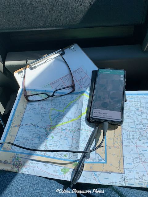
Maybe you are thinking I only take photos on these geocaching county road trips. This is how my lap looks. The clipboard holds all of Hubby's pre-trip planning and organization with lists and maps. The state map has the day's roads highlighted. My job is to get us on the right road. (That doesn't always happen.) The phone allows me to see the geocaches as we drive, if we have cell service. I am checking to see if the cache has been found recently, if there is a more interesting cache in the area, if the geocache is in the county we thought it was (sometimes human error plays a role), etc. The phone also is used to get us onto the correct street in a community and to know if the streets are dead ends, or even drivable. Hubby depends on a compass. I depend on a map. It can be a bone of contention sometimes.
Day 2 TX Road Trip next.
Some very cool sites you have seen! I know that cache and cemetery you mentioned as a hard one... I agree, but then RR is a tough cache hider most of the time. Looking forward to your next installment.
ReplyDelete