Wednesday, August 14, 2024

WY Geo Wrap-up


As I said in the beginning of this series of blog posts, the trip to Wyoming was two-fold: to see the Grand Teton National Park and to geocache in seven counties where we had not geocached before. This post is about the geocaching. Only our geocaching friends might be interested in the wrap-up.

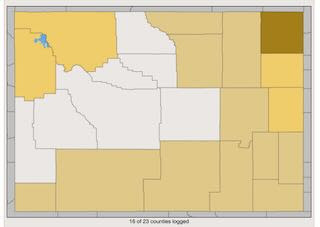
This was the Wyoming map before this trip. Seven of the 23 counties were open.


It was at this location in Buffalo that I reached 31,000 geocache finds. Hubby has about 800 more geocache finds than I do. 


Big Horn County ✔


Worland WY
Washakie County ✔


Hot Springs County✔


large geocache in Shoshone


Fremont County✔


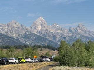
road trip to Sublette County✔ and Lincoln County✔


 location in Jackson of the geocaching event I hosted 
on Thursday early evening
two local geocachers attended


location of a letterbox cache in Jackson


a large travel bug cache in Jackson


We had geocached in Teton County when we were in Yellowstone National Park 2021.
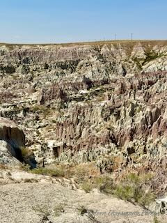
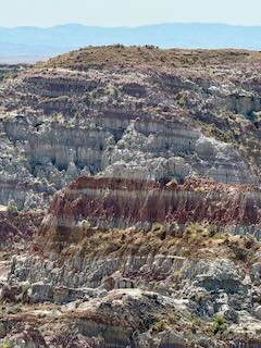
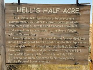

Natrona County✔
geocaching mission complete!


Geocache total on this trip: 65

30 Traditionals

4 Unknown

5 Virtuals

9 Earth Caches

1 Letter Box

1 Event

3 Adventure Labs for 15 more caches

Wyoming makes the 6th state in which we have found a geocache in every county. (South Dakota, Arizona, Nebraska, Minnesota and New Mexico) There are 3144 counties in the United States and we have found a geocache in 935 of them. We have met a couple of geocachers who have found a geocache in all 3144 counties! That is amazing.


Tuesday, August 13, 2024

Grand Teton National Park

 Grand Teton National Park is in the northwest of the U.S state of Wyoming. It encompasses the Teton mountain range, the 4,000-meter Grand Teton peak, and the valley known as Jackson Hole. It’s a popular destination in summer for mountaineering, hiking, backcountry camping and fishing, linked to nearby Yellowstone National Park by the John D. Rockefeller, Jr. Memorial Parkway. ~ National Park Service


We got some advice from a local geocacher: the sky might be less smoky earlier in the morning AND you might have a better chance of seeing wildlife earlier rather than later. We were on the road before 9 on Friday morning. Our first stop was Teton Village.


see all those ski slopes?


A warning for all the hikers and campers in the Grand Teton National Park. We did not see any grizzly bears.


The road through the lower end of the Teton Park area.


Justin, the park employee and local geocacher, was right. That is Mt. Teton in the center of the photo.


The sky was far less smoky than on Wednesday when we arrived.


This was the line-up to enter the national park.


This was Wednesday's photo. On Friday we were hours earlier and our location was near the tree line just at the base of the mountains. This photo was taken from the highway, maybe 5 or so miles farther away.


We stopped at an informational sign displaying and explaining the receding Teton Glacier. 


My red arrow is pointing to the Teton Glacier. There just has not been the snow pack in the last 30+ years to help maintain the glacier's volume. And yes, warmer temperatures affect the glaciers. This is what I learned about glaciers:

What are Glaciers?
Glaciers must meet three main criteria in order to be characterized as glaciers:
1. They must be made of ice. (They also contain air, water and rock debris but they MUST contain ice crystals)
2. They must initially form on land (they cannot start out forming over water) and may eventually extend out into water.
3. They must move! (If a patch of snow or ice does not move it is not a glacier.)


Mt. Moran is a 'flat' topped mountain in the Teton range because it's top was once a lake bed and beach!


Jenny Lake named for the wife of Beaver Dick Leigh. Their bronze statues were seen while geocaching in Jackson and in a post from Saturday, August 10. It is a glacial fed and spring snow melt lake.


another view of Jenny Lake


Mount Moran with its glacier (not a natural arch) in the center.


No wildlife sightings on Friday. We did see some tour vans with tourists hoping for a sighting of elk or bison or grizzly.


We camped near Wilson, a 'suburb' of Jackson for four nights.


This was the view of Teton Mountain on Sunday morning when we left the Jackson Hole area. It was about 9:30 in the morning and the photo is through the windshield. No smokey skies...yet.


We got lucky and saw the herd of bison near Moran when we left on Sunday. 

I am glad we visited the park. It is so different from Yellowstone National Park, which I knew it would be. Other than the majestic mountains, the park itself is unostentatious, in my opinion. I learned a lot from the display signs. We probably would not have stopped and read each of them if not for geocaching.


Monday, August 12, 2024

Hell's Half Acre

 On our drive from Jackson to Casper, we came upon the most amazing geological phenomenon, because of geocaching.

There is only a little sign along the highway and this sign at the entrance. It would be very easy to miss, or just drive by not realizing what you were missing. Photos do not do justice to what we saw.


The 150-foot-deep gorge, and the badland features were created through differential erosion by wind, gravity and intermittent streams flowing south into South Fork of Powder River. The gorge consists of layers of claystone, siltstone and sandstone.


Erosion over millions of years is responsible for the unique landscape of unusual features of hoodoos and pinnacles.


It looked like black foam was resting on the top of the pinnacles. So interesting!


A closer photo of the black foam, but it still doesn't show what I saw.


The floor of the canyon was white.

Encompassing 320 acres, this geologic oddity is composed of deep ravines, caves, rock formations and hard-packed eroded earth. Hell's Half Acre was used as the location for the fictional planet of Klendathu in the 1997 movie Starship Troopers. ~ Wikipedia


There is evidence the Native Americans used the area for a bison jump. Bones and flint arrowheads have been found. They also drove herds of elk and deer over the cliff edge.


It was known as "The Devil's Kitchen", "The Pits of Hades", and "The Baby Grand Canyon" - terms to entice tourists to the area. A cowboy stumbling upon it thought he was in an area of alkali and bogs known as Hell's Half Acre, giving it the name that is used today.


According to the government site for Natrona County:  Hell's Half Acre is a large geological formation that encompasses over 960 acres, including Castle Arch. 


Being from South Dakota, I have seen the Badlands. I have also been to the Grand Canyon and most of the national parks in Utah. This little known canyon in Wyoming rates just as high (or higher) than the national parks.


The colors and the shapes...all were close enough to the edge. There was so much more area we could not see.


I see a foot holding a rabbit head wearing a hat. What do you see?


More pinnacles holding larger, heavier layers of sandstone or claystone or siltstone.


At one time there was a restaurant, motel and campground at this location. They were closed and removed in 2005 due to lack of visitors. An 8' wire fence surrounds the area. One corner of the fence was open and safe for visitors to slip through and stand on a safe ledge for more photos.


There were visible caves along the far walls.


Natrona County is the caretaker for Hell's Half Acre. Wyoming PBS has published an episode of their series "Our Wyoming" on Hells Half Acre. The YouTube piece gives great information of the past and their hope for the future of Hell's Half Acre. (click on the episode link)