Saturday was our last day in the Jackson Hole area. So it was a day to geocache as we had already spent time in Jackson and drove through Grand Teton National Park on Friday.
By the way, I asked a local to explain the difference between Jackson and Jackson Hole. Jackson is the Teton County seat with a population around 10,000. Jackson Hole is the valley between the Teton Mountains on the west and the Gros Ventre Mountains to the east. So if someone says they are in Jackson Hole, they could be anywhere within the county of Teton.
We learned about a slide (avalanche) that happened in 1925 in the Gros Ventre Mountains. Since we had explored the Tetons, we headed east to the mountain range Saturday morning. There were three geocaches and they became our destination.
We started on the floor of the valley, heading to the unincorporated village of Kelly. It has a post office and a population of maybe 100. The history of Kelly is important to Saturday morning's destination.
Kelly, Wyoming was initially a modest but thriving rural town located on the banks of the Gros Ventre River. Around 1925 the town had many amenities: mercantile, Riverside Hotel, blacksmith, flour mill (1917-1921, burned), dance hall and sawmill (removed 1918). In 1904 the first school opened on the Warren Henry homestead.
By 1909, families from the surrounding area began constructing small cabins in Kelly to stay in while their children attended grade school. In 1914 the town was approved for a post office, which remains open today. Prior to this, Kelly was known locally simply as “Bridge.” The name illustrates the importance of the timber bridge that spanned the Gros Ventre River, one of the few early bridges built in the valley. There were few options in the valley for safe river crossings, and the Kelly Bridge was one of four until the mid-1920s. ~ History Jackson Hole
As we climbed in elevation the terrain changed from scrub brush and grasses to poplar trees.
In 1921, Kelly competed against Jackson for the Teton County seat, losing by only 26 votes. Just six years later in 1927, Kelly would be obliterated by a severe flood. The flood destroyed the town, leaving only the school and church intact. Everything else was flattened or swept downriver. It took the town decades to rebuild, but it would never reach the level of prosperity that it had enjoyed prior to the flood.
Six people lost their lives in the 1927 flood which was caused by the Slide.
Today, Kelly is a small community within the eastern boundary of Grand Teton National Park. Both the school and the church that survived the flood did not, however, survive the fire that destroyed both in 1971. Because of these two disasters, the town of Kelly has few, if any, historic structures.
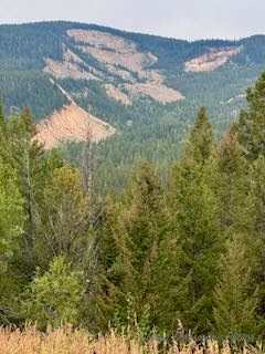
This was the view of the slide or avalanche when we stopped for the first cache, Cache Across America.
There is one geocache in each of the fifty states called Cache Across America. This is the location for the WY one. South Dakota's Cache Across America is located in Watertown. (Curt is putting his gloves on, not doing what you might think looking at my photo!)
The slide occurred on June 23, 1925. Heavy rains and melting snow may have been part of the cause, but small earthquakes were also reported around that time. In just 3 minutes, 50 million cubic yards of sedimentary rock slide down the north face of Sheep Mountain. The force of the landslide crossed the Gros Ventre River and rose 300 feet up the mountainside across the river, obliterating everything in its path. The landslide created a dam 200' high by 400 yards wide across the Gros Ventre River, creating the Lower Slide Lake.
"On May 18, 1927, part of the landslide dam failed, resulting in a massive flood that was six feet deep for at least 25 miles downstream. The small town of Kelly, six miles downstream, was wiped out, killing six people. It is one of the world's largest known examples of recent mass wasting events aside from volcanic eruptions. Slide Lake is now much smaller than before the flood." ~Wikipedia
The US Forest Service has a document of the 1925 and 1927 events sharing first person accounts.
With that mission accomplished we decided to drive Teton Pass to the Idaho border to find three more geocaches. We headed west driving through Wilson, a quaint village at the bottom of Teton Pass serving great food, unique activities and outdoor adventure.
Our destination for the afternoon drive, which took maybe 30 minutes for the 10 miles.
Hubby made a U-turn at the two wide pull-outs to get the Wyoming sign. We found the geocache and headed back down the mountain.
A beautiful view heading down the mountain.
Teton Pass is NOT for the faint of heart, especially going down. I am so glad we were not towing the travel trailer!
Location of another geocache in a large and busy pull off area. Bikers and hikers use it as a starting location. While Hubby found and signed the geocache, I took photos of wild flowers as I had seen so few in this area of Wyoming.
The view of the valley from the sign post. Welcome to Jackson Hole
I had forgotten to bring my trusty, old digital camera on this trip. I had planned to do so, but it is still at home. I LOVE the layering of the mountains as we descended into the valley. The iPhone did a decent job. I am happy with the outcome.
And just when we thought our celebrity encounter was hard to top, we saw wildlife on Saturday night on our way to the campground after dinner.
This moose was walking and eating along the bike/walking path that runs along the very busy road near Wilson.
We saw cars pulled over to each side of the road and as we passed, we saw the moose. Hubby let me out and I joined the folks gathered just off the road to take photos of the moose eating. WOW! A live moose! We have seen all we came to see. Now we can head east toward home.


.jpeg)
No comments:
Post a Comment
Thanks for your comments!