After the event at San Tan Flat we headed back to the desert west and south of Phoenix to continue to look for shot gun shells hidden under rocks in a desolate part of the desert. Hubby had a plan for gathering those last geocaches closest to Gila Bend.
Since we have been on these roads several times, you have seen photos of the landscape, the lava hillsides, the dormant volcanoes, the flora. Believe me, nothing has changed since the trip in December. So there are very few photos from this adventure.
The plan was to drive as far as the scary trench because we did not plan to drive through it again. We would find the geocaches from the southwest side and work back to Gila Bend. Then we would drive in from the north and work the railroad road back to Buckeye area. That was the plan.
We drove to the trench and I realized it was NOT 20 or 30 feet deep. I said I would be willing to drive through it again. Change of plans.
In fact, when we did drive through it the next day, it was far less scary than some of the unknown roads we had been on earlier in the day!
We were driving on 'roads' on the western side of Woolsey Peak Wilderness. Translated that means, rocky ridges, rocky steep washes, and rocky 'roads.' I have never thought of myself as being carsick, but I cannot eat before, during or after being on those roads.
Large rocks were wired to the fence post or fence wire (I did not look that closely) to keep the fence line taunt. I can think of no other reason someone would move small boulders and wrap them in wire.
The one interesting addition to the road was this car. It was not there on our last trip.
No one will be driving it out of the area. I was hoping we would NOT come across a dead body on the trip. Hubby was hoping we would not come across someone walking.
Although the landscape was not that rugged in that particular area, it certainly was not a road to take the family sedan! The trench was less than a mile east of the location and sandy washes and rugged rocky roads to the west. I'm betting there is a good story behind the abandoned car.
We did see some animals on this trip. Four coyotes were in a field, moving quickly so getting the camera out of the bag and ready for photos was out of the question. At one geocache location we startled a jack rabbit. We saw lots of geckos and thankfully, no snakes...rattlers or other kinds.
This road trip was also a test of Hubby's fix-it job on the hole in the passenger side floorboard would keep out some of the dust.
This is just to show the tenacious root systems of some desert plants. Most of the roots are not in the soil, but the shrub is green and growing.
We drove the same bumpy, dusty roads we had driven on the last trip. Yes, the interior of the jeep is dusty and dirty, but NOTHING like it was the last trip.
(Photos on this blog post.)
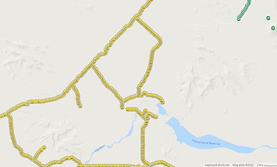
This is the satellite map of the area with the bumpiest, rockiest road with steep washes. You can see why looking at the terrain. This was a short (time -wise) two day trip after revising the original plan.
We added the yellow smileys above and to the left of the bodies of water.
After driving through the trench we headed northeast to the main road, and then getting some of the caches to the west and to the east on the main road. As you can see there are more shotgun shells to find, but it won't be this month. Like a long pregnancy of morning sickness and a hard labor, I need at least 9 months before going back out there!


No comments:
Post a Comment
Thanks for your comments!