

Our walk that very warm morning was about 0.6 miles. I walked the wrong way to start with. The road was a gradual incline, but up hill none-the-less. The temps were well into the 80s at the time. I was so happy to see...


The tunnel was built in 1922 and named for the community of Claypool, about 20 miles to the east.

One of the bore holes in the tunnel walls

Other holes placed higher on the tunnel wall.

The more modern two lane Queen Creek Tunnel replaced this tunnel in 1952 when Highway 60 was rerouted and modernized with more bridges and tunnels through the canyon alongside Queen Creek.

Highway 60 is above that canyon wall.

Hubby located the cache without finding any snakes, lucky for us!

The other side of the canyon wall along Queen Creek.
(Diane: this is the area where we stopped to take photos when you visited two years ago. The rock formation where your photos were taken is where we parked the jeep. Hubby and I walked down below that formation.)

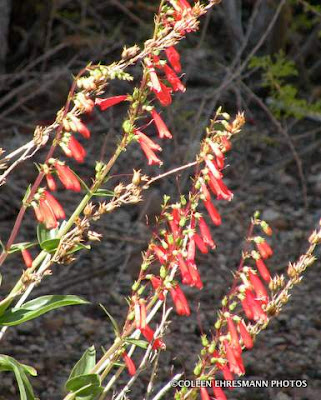
These red flowers were along the old highway.

They are similar in shape to blue bells. I have not looked up their name.

Our final stop of the morning was another cache in the town of Superior along the Superior History Trail.

All the towns in this area began because of mining; Superior, Miami, Claypool, and Globe all along this section of Highway 60. A very large open pit copper mine is south of Superior. Although we did not visit the mine this year, we did stop by last season, but I did not post any pictures of that stop. My last posting was from 2010.

We did not take the time to enter the Visitor's Center. Maybe on our next visit. Five geocaches that morning and another destination off my bucket list!
(Because of the heat, this was/is our last geocaching adventure until we begin our journey home next week/this week. There will be one more caching post, but it occurred prior to this one.)
No comments:
Post a Comment
Thanks for your comments!