When we traveled the first half of the road for a hike, I was not impressed. The hiking club has the trip listed as 32 miles, 16 on a dirt road. The trip to the trailhead is LONG, and the hike is longer...3.5 miles downhill and 3.5 miles uphill on the way out. (I know it was billed as a five mile hike until someone brought a GPS along.) My first and only time on the road and the hike bring back memories of a older woman (well, older than me!) who had problems (diabetic related) on the way out of Roger's Trough, stumbling and falling on the rocky trail as she struggled to climb up and out. On the way back to the resort on that trip, a truck overheated, needed water and duct tape to make it back down the 32 miles. We got back to the resort after dusk turned into dark. One of the hikers was worried about his wife being alone so long (about 10 hours) as she was in early stages of dementia. When we dropped him off as his RV, it was completely dark. He shared later his wife did not remember how to turn on the lights. (He never hiked without her along thereafter.) So you can understand why I have no fond memories of the trip or the hike.
Hubby has hiked it just one other time since that first time in 2006 or 2007. He stayed with a gentleman who was having problems making the trip back out of the canyon. Again, the hike took much longer than it should have as the other hiker was stumbling on the rocky path. On the way back to the resort Hubby was riding in the back of a crew cab having leg cramps most of the 32 miles. He said NEVER again.
Well, today we had to eat our words as we did indeed travel the 16 miles on dirt road and another 22 to complete the loop and find the elusive geocaches. I have learned that geocaching takes you to places you would not venture if not for the thrill of the hunt. I will say the road has NOT improved since 2006 or '07. Neither of us plans to go back and make the dirt road 38 mile loop. But I will share some of the awesome, delightful, interesting parts of our Valentine Day adventure.

Little Red didn't look this clean at the end of our adventure!

A couple of planes spent a lot of time flying in the area.
We learned it was the forest service doing some training maneuvers.
Interesting looking plane.

We weren't the only people out and about on the dirt roads.

The grass is so green and lush from the recent rains.

It bothers me how much litter is left by others.
But I didn't pick it up, either. I should have.
I don't leave any litter on our trips, either!

There were lots of tall stately saguaros at the lower elevation.

It is hard to show the kind of roads we, no, Hubby drives.
When the road requires 4W drive, I certainly don't hop
out for a photo. I am hanging on for dear life!

I did see some wildlife today.

The flicker is the same species who enjoyed eating
out of the hummingbird feeders in the yard.

This is the beginning of the Montana Mountain Range.
(I believe I'm right on this.)

This saguaro is NOT stately.
I'm not sure if the holes are natural as other cacti
in the area do not look like this one, or if the holes
are a result of gun/rifle shots.
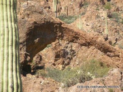
This natural arch was one of the first surprises along the first
16 miles of dirt road. Hubby said he was told to look for it on his last
hiking trip. No one shared it with us on our first road trip.
Glad there was a cache nearby to point it out to us.

In fact there are two natural arches.
The one of the left is much smaller, but still
very awesome.

More healthy, stately saguaros.

There was a cache along this stream.
I loved the sparkle of the sunshine on the water.

This tree made a lovely arch.

Another old tree framed the running water.

We stopped here for lunch, at this cache location.
I was so busy focusing on the stream and the sunlight
and the interesting trees, I forgot to look anywhere else.
I have learned from Scott Shephard, my mentor photographer
to turn around, as the perfect picture may be there, behind you
instead of only in front of you. This was the view behind me.
Equally awesome.

The beginnings of a crested cactus, one of the anomalies
of the saguaros. I posted a whole series of photos last spring
of crested saguaros. This one was not on that posting.

Do you see the roads in the photo?
That is where we have come from.
The Superstition Mountains is the one farthest back.

Can you find the gecko in this photo? He is there.
Head towards the upper right corner.
Tail towards the lower left corner.
He blends so well with the brush stems.

I enjoy trying to get good photos of the varying mountain
ranges. This one includes a layer of smog between the
mountains and the blue sky.

Someone built/made this rock heart shape at one of
the cache locations. I thought it was so appropriate
for Valentine's Day. Hubby did not notice until
I showed him the photo. We do see different things.

We have left the saguaros behind.
Elevation at this point is over 4000' above sea level.
I took this photo showing the results from a fire that went
through some time ago.

Looks like more than 22 miles, doesn't it?
The road was not as smooth as it looks either.
But it was a road. We knew where we were.
We got to the highway before dark.
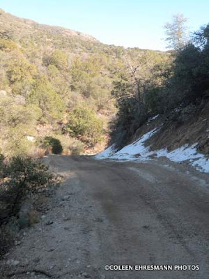
There was snow along the dirt road, especially
on the north side of the mountains once we made
it to the top and started heading down on the east side.

I noticed these two littered beer cans as we stopped
to cache near the end of our journey. I can not imagine,
believe or understand why someone would attempt
driving the road while drinking. Absolutely Insane!

I had a number of favorites on this adventure, but this stone
house is my MOST favorite. I wish I knew the story behind
the abandoned structure. Maybe driving the road to get to
the house drove the owners over the edge.
It would me!
A writer of the Arizona Highways magazine wrote an article about traveling this same road with an off-road driving enthusiast. She, Kathy Ritchie, called the trip a white-knuckle experience, on gnarly roads, climbing vertically, crawling over small boulders, branches scratching the side of the vehicle (SUV), narrow road hugging the mountainside like a ribbon with no room to pass and no guard rail, and finally an endless descent down a rocky hill made of nauseatingly tight switchbacks.
Yep. We were on the same road! I'm just glad I have some photos of some of the more awe inspiring sights to help erase the vertical climbs over small boulders and nauseating switchbacks on the descent.
Even though we did find 22 caches I am NOT doing it again. Ever! I mean it, too! Never.
Does red have a name yet? I think she needs a name soon!! Sounds like you had a great time traveling the trails around Montana Mountain!!
ReplyDeleteLiz, she is named Little Red to distinguish our red jeep from the other larger, newer red jeeps in the resort. Her name was selected on the way to Yuma. It is official! ha ha ha
ReplyDelete