Sunday, October 30, 2016

Arrival & Wrap-Up

It had been maybe two years since we arrived at CV by way of Payson & Highway 87. The drive was as good as it gets on Monday morning, sunshine & light traffic.


seeing some elk would have made it even better
as long as they were crossing the road at their crossing


I look for the first sightings of saguaros
means we are almost there...


just a few more miles
Superstition Mountain


have not had exciting sunsets this week
did have MANY vapor trails one afternoon


we ended our first week at CV by attending
a geocaching event


good to see some of our winter caching friends

We got the travel trailer washed, unpacked and in storage within two hours of arriving. We've stopped to say "Hi" to friends and neighbors who are also here. The shopping is done. Camper laundry is done and packed away. There is a new ceiling light & fan in the bedroom. No major projects on the agenda as everything is working. We dug out the sick looking cactus and have replaced it with metal decor. When the 90ยบ+ temps are gone, I will work outside on the decor. We are feeling settled.  It is good to be at our winter home. 

GeoAdventure wrap-up: 
we were gone 24 days
geocached in 16 states; 7 of which were new geocaching states
we added 746 geocaches to each of our totals
we traveled 5397 miles
we added awesome memories


Tuesday, October 25, 2016

State #16 ~ The End of the GeoAdventure

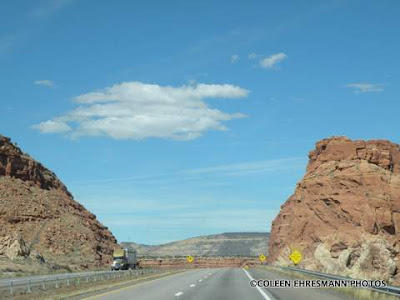
We, yes WE, drove across New Mexico on Sunday. We were congratulating ourselves on choosing a day with less big truck traffic on I 40 and winds of 7 mph. Sunshine and temps to reach the high 70s. A perfect day for driving.


few trucks
wide open spaces
red rock
that lasted the first 20 miles
then...
many more trucks
winds whipping over and around the mountains
and lots of dry, brown nothingness
that's new Mexico


scenery after Albuquerque, closer to the AZ border


interesting colors


years of winds and water erosion


a stop at the border


never noticed the animals before


but then again, we have never stopped before


we did today to get State #16 geocache


some of my favorite scenery along I 40

Less than 200 hundred miles from our winter casa. I think I will post a summary of miles and caches when we are settled in a few days. Let the fun at Senior Camp begin!

Monday, October 24, 2016

Cadillac Ranch

When Hubby said we would be going through Amarillo, a stop at Cadillac Ranch was on MY Must Do List. We saw Cadillac Ranch when we drove through the Panhandle in 2010 on our way from AZ back to SD in the spring, but we weren't geocaching then. Now that geocaching comes into play, we stop at places he may not have in the past. My Canadian friend Dianne posted about Cadillac Ranch on her blog when they went through that part of Texas. After seeing her photos, I have wanted to see the Cadillacs once again.


the place has become so popular a tour bus was there 
when we stopped


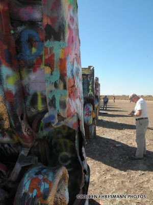
10 Cadillacs planted nose down in the ground


people come with their cans of spray paint
to decorate the cars...


...and the sorghum
unfortunately many leave their empty cans of paint 
lying on the ground


WHY?
WHY are 10 Cadillacs buried in the ground?

"The Cadillac Ranch, located along the tatters of historic Route 66, was built in 1974, brainchild of Stanley Marsh 3, the helium millionaire who owned the dusty field where it stands. Marsh and The Ant Farm, a San Francisco art collective, assembled used Cadillacs representing the "Golden Age" of American Automobiles (1949 through 1963). The ten graffiti-covered cars are half-buried, nose-down, facing west 'at the same angle as the Cheops' pyramids."

"Cadillac Ranch was originally located closer to the city in a wheat field, but in 1997 the installation was quietly moved by a local contractor two miles to the west, to a cow pasture along Interstate 40, in order to place it farther from the limits of the growing city. Both sites belonged to the local millionaire Stanley Marsh 3, the patron of the project. Marsh was well known in the city for his longtime patronage of artistic endeavors including the "Cadillac Ranch", Floating Mesa, "Amarillo Ramp" a work of well known land artist Robert Smithson, and a series of fake traffic signs throughout the city known collectively as the "Dynamite Museum". As of 2013, Stanley Marsh 3 does not own the Cadillac Ranch.

Cadillac Ranch is visible from the highway, and though it is located on private land, visiting it (by driving along a frontage road and entering the pasture by walking through an unlocked gate) is tacitly encouraged. In addition, writing graffiti on or otherwise spray-painting the vehicles is now encouraged, and the vehicles, which have long since lost their original colors, are wildly decorated. 
The cars are periodically repainted various colors (once white for the filming of a television commercial, another time pink in honor of Stanley's wife Wendy's birthday, and yet another time all 10 cars were painted flat black to mark the passing of Ant Farm artist Doug Michels or simply to provide a fresh canvas for future visitors. In 2012 they were painted rainbow colors to commemorate gay pride day. The cars were briefly "restored" to their original colors by the motel chain Hampton Inn in a public relations-sponsored series of Route 66 landmark restoration projects. The new paint jobs and even the plaque commemorating the project lasted less than 24 hours without fresh graffiti."

Sunday, October 23, 2016

States #14 & #15 of the GeoAdventure

We are nearing the end of the 16 State GeoAdventure and like a "horse headed for the barn" we are both ready to reach our winter home.

We now have 103 caches in Oklahoma. Time to move along.


State #14


we were in farming country today
we also noticed this part of TX is very dry
after seeing all the green in the upper midwest
and the trees in the southern states,
the dry grass of TX was almost a shock
some farmers/ranchers were feeding hay to their stock
pastures were short and brown


another interesting water tower
center pole was straight
frame wasn't


Groom TX


State #15
we stopped at this location to get a geocache
we parked as safely as one can with a truck and travel trailer
and spent a lot of time looking
while we were intent on our search
an 18 wheeler driving past blew a tire
it was so loud...like a gunshot
and black tire flying everywhere
happened maybe 100' down the road
lots of screeching and braking of vehicles, too
we were safe
didn't find the cache, either...bummer
had to get one farther into New Mexico


We will drive across New Mexico on Sunday. It was a very windy day for driving on Saturday. New Mexico is always windy. Maybe there won't be as many big trucks on I 40 being it's Sunday. One can hope...

(Foggy photos are those shot through the windows.)

Saturday, October 22, 2016

Oklahoma City

We had two reasons to spend some time in Oklahoma City on this final leg of the 16 State GeoAdventure. This was the first:


The second was to visit the Oklahoma City National Memorial.


"On April 19, 1995 at 9:02 AM, an unprecedented terrorist attack occurred in the heartland of America. 168 men, women, and children perished in this attack. A monument to those lost has been created at the site."  


Reflecting Pool 
thin layer of water over polish black granite
West Gate of Time


The Field of Chairs

"168 empty chairs hand-crafted from glassbronze, and stone represent those who lost their lives, with a name etched in the glass base of each. They sit on the site where the Murrah Building once stood. The chairs represent the empty chairs at the dinner tables of the victims' families. The chairs are arranged in nine rows to symbolize the nine floors of the building; each person's chair is on the row (or the floor) on which the person worked or was located when the bomb went off. The chairs are also grouped according to the blast pattern, with the most chairs nearest the most heavily damaged portion of the building. The westernmost column of five chairs represents the five people who died but were not in the Murrah Building (two in the Water Resources Board building, one in the Athenian Building, one outside near the building, and one rescuer). The 19 smaller chairs represent the children killed in the bombing. Three unborn children died along with their mothers, and they are listed on their mothers' chairs beneath their mothers' names."


The Survivor Tree

"An American elm on the north side of the Memorial, this was the only shade tree in the parking lot across the street from the Murrah Building. Commuters arrived early to get one of the shady parking spots provided by its branches. Photos of Oklahoma City taken in the 1920s show the tree to be about 100 years old. The tree was taken for granted prior to the blast. Heavily damaged by the bomb, the tree survived after nearly being chopped down during the initial investigation, when workers wanted to recover evidence hanging in its branches and embedded in its bark.

The force of the blast ripped most of the branches from the Survivor Tree, glass and debris were embedded in its trunk and fire from the cars parked beneath it blackened what was left. Most thought the tree could not survive. Almost a year after the bombing, family members, survivors and rescue workers gathered for a memorial ceremony by the tree noticed it was beginning to bloom again. The Survivor Tree now thrives, and the Outdoor Memorial design includes a mandate to feature and protect the tree. For example, one of the roots that would have been cut by the wall surrounding the tree was placed inside a large pipe, so it could reach the soil beyond the wall without being damaged. The decking around the tree was raised several feet to make an underground crawlspace; workers enter through a secure hatchway and monitor the health of the tree and maintain its very deep roots."


the time over the east entrance representing the last moments of peace
the 9:03 over the west bronze gate represents the moment recovery began


some of the wall of the original building
left as a reminder

"On April 19, 1995, Timothy McVeigh parked a Ryder rental truck filled with explosives in front of the Alfred P. Murrah Federal Building. The resulting explosion killed 168 people and destroyed the entire north face of the building."


a beautiful, somber area...a city block wide
East Gate of Time


"And Jesus Wept"


"Across the street from the 9:03 gate is a sculpture of Jesus weeping erected by St. Joseph's Catholic Church, one of the first brick-and-mortar churches built in the city. Jesus faces away from the devastation, covering his face with his hand. In front of Jesus is a wall with 168 gaps in it, representing the voids left by each life lost."


Then it was off to the Capitol building for some geocaching


inside the visitor's center


"Oklahoma City sits on top of one of the largest petroleum fields in the world, with the State Capitol building located very near the center region. The field is approximately 12 miles long and 4.5 miles wide, encompassing 32 square miles, with a productive area of 13,770 acres."


"The state capitol complex is famous for its oil wells and remains the only state capitol grounds in the United States with active oil rigs."


We also stopped at the 45th Infantry Division Museum. 
What a treasure! 

there must have been almost 100 units on display


from WWI through the Korean Conflict 


and Desert Storm


a MASH vehicle


Hubby is standing on a Bailey Bridge
his first National Guard unit used the Bailey Bridge
in the 1972 Rapid City flood to replace washed out
roads and bridges


he said 'rods' were placed in the square holes
six soldiers would carry that bridge piece and place it 
where needed, building the bridge


an early Howitzer


Hubby also drove a similar Deuce and a Half to pick-up food rations
 for his Guard Unit while at camps in the US
he was a cook


loved that warning signs had to be placed in obvious places


displays inside the museum


from early conflicts ~1800s


through more recent wars


Hubby with his boyhood hero Mickey Mantle
in the Brick Town area of OKC


three states and three days from our winter home