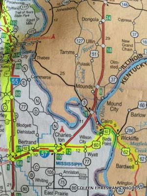
Hubby's route
shorter route...Hwy. 3 in IL
without crossing the Mississippi River
In my defense, as I am the navigator, I was doing the following as we crossed that narrow bridge (see KY post) over the Ohio River: taking photos (he told me to do so), holding my breath as we met semi trucks, listening to the scraping, rubbing sounds and thinking OMG, and watching Hubby drive. There was no time to look at the map and the 'new, shorter directions.' (I had made the phone call at Wickliffe, about 5 miles from the first bridge.) I had asked for directions from Cairo (pronounced Care-o) but we weren't planning to go to Cairo. I also had those direction up on my phone.
We continued on Hubby's planned route, and almost immediately crossed the Mississippi River on a second just as narrow, harrowing bridge. More rubbing sounds. More 'held my breath' moments.

State #12
Neither of us wanted to recross either of those two bridges. As soon as it was safe, we stopped and checked the side of the travel trailer and the truck tires. Everything was OK. The rubbing and scraping must have been the semis.
We checked the map and the new directions and realized we had missed our turn. Since we were in Missouri, we decided to go to the nearest town, Charleston, and get a geocache and then head north for our reserved camping spot. We looked at the map, the phone, the truck navigation system and said, "Got it."

geocache at Boomland
a truck stop, store and tourist info
reminded me of Wall Drug, but I did not go inside
first MO geocache

GOOD bridge on I 57

and crossed the Mississippi a second time within an hour


State #13
We got down the road and exited when I thought we should get off. We started toward Cairo, but decided it couldn't be the right road, so back to I 57. (By this time we had decided to take Hubby's planned route and forget about the shortcut.) That is when I realized we were going in the wrong direction...Chicago, not St. Louis. Crap! We took the next exit at Mounds, and hoped there would be a road heading west to Hwy. 3. The paper map wasn't helpful. The truck navigation map finally showed us the road we needed, paved and wide, taking us west to IL Hwy. 3 and Cape Girardeau. They were good roads, wider than the TN & KY roads earlier in the day. It was a little later in the evening than we like to be driving when we are not familiar with the roads or destination.

another bridge, with road construction!
even with road construction it was wider
than the first two

beautiful lighted bridge leading from IL to MO
and Camp Girardeau

We had to get the manual to find all the tools and their location needed to change the tire, how to release the truck spare, how to work the tools, etc. It was definitely a two-person job. My role was 'go-fer' and read. Hubby did all the heavy work. Thank goodness for extra jacks (used with the camper for stabilizing) as the one supplied by the truck did not fit under the axle until the truck was lifted with the other jack.

first mission accomplished

second mission accomplished

that IS flat
We picked up a nail somewhere later the previous day as the tire pressure sensors did not indicate low tire pressure when we were driving the night before.

11:30 departure from Cape Camp
onto Granite City, our 'home' for the next 5-7 days
and a much needed R&R day for one more errand
fix the truck tire
Oh my gosh, I could feel myself getting anxious as I read the blog, it was like I was riding in the back seat ha ha. Narrow bridges......pulling a trailer, coming into the campground later than you wanted........
ReplyDeleteGood thing you were at the park when you saw the flat. What a pair, working together, good job guys!!!!!